Kunhegyes geodata
Kunhegyes (Jász-Nagykun-Szolnok) is a seat of a second-order administrative division; located in Hungary in Europe/Budapest (GMT+2) time zone. With population of 8,462 people, there are 189 cities with bigger population in this country. Compared to other cities in Hungary, 53.1% of cities are located further ↑North; 73.3% of cities are located further ←West and 87.7% of cities have higher elevation than Kunhegyes. Note1


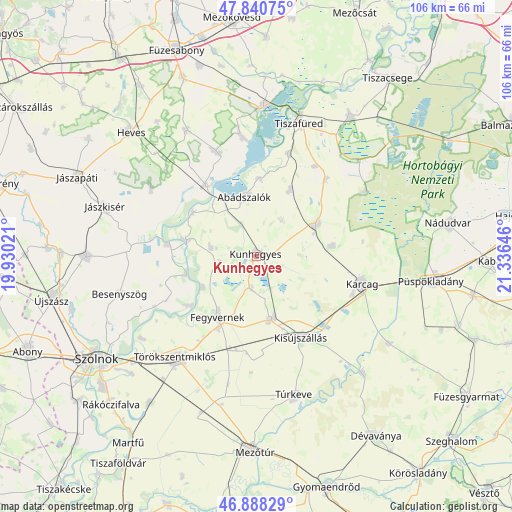
Kunhegyes GPS coordinates[2]
47° 22' 0.012" North, 20° 37' 59.988" East
| Map corner | latitude | longitude |
|---|---|---|
| Upper-left | 47.84075°, | 19.93021° |
| Center: | 47.36667°, | 20.63333° |
| Lower-right: | 46.88829°, | 21.33646° |
| Map W x H: | 105.9×105.9 km | = 65.8×65.8mi |
| max Lat: | 48.46667° ⇑53.1% North |
| Kunhegyes: | 47.36667° |
| min Lat: | ⇓46.9% South 45.79108° |
| min Long | Kunhegyes | max Long |
| 16.27358° | 20.63333° | 22.68096° |
| W 73.3%⇐ | ⇒26.7% E |
Elevation
Elevation of Kunhegyes is 88 m = 289 ft, and this is 41.7 m = 137 ft below average elevation for this country.
| Max E: |
444 m = 1457 ft | 87.7% |
| Avg. | 129.7 m = 426 ft | |
| Kunhegyes | 88 m = 289 ft | |
Min E: |
71 m = 233 ft | 12.3% |
See also: Hungary elevation on elevation.city.
Geographical zone
Kunhegyes is located in North temperate zone (between Tropic of Cancer and the Arctic Circle). Distance of this North polar circle is 2134.5 km =1326.3 mi to North.| Distance of | km | miles | from Kunhegyes |
|---|---|---|---|
| North Pole | 4740.4 | 2945.5 | to North |
| Arctic Circle | 2134.5 | 1326.3 | to North |
| Tropic Cancer | 2660.8 | 1653.3 | to South |
| Equator | 5266.7 | 3272.6 | to South |


Nearby cities:
15 places around Kunhegyes: (largest is in red/bold)
• Abádszalók
11.4 km =7.1 mi,  347°
347°
• Fegyvernek
13.4 km =8.3 mi,  214°
214°
• Karcag
23.3 km =14.5 mi,  103°
103°
• Kenderes
13.5 km =8.4 mi,  163°
163°
• Kisköre
17.9 km =11.1 mi,  325°
325°
• Kisújszállás
19.5 km =12.1 mi,  148°
148°
• Kunmadaras
14.6 km =9.1 mi,  59°
59°
• Tiszabura
15.6 km =9.7 mi,  306°
306°
• Tiszabő
13.5 km =8.4 mi,  236°
236°
• Tiszanána
23.5 km =14.6 mi,  341°
341°
• Tiszaroff
14.3 km =8.9 mi,  285°
285°
• Tiszaszentimre
15 km =9.3 mi,  30°
30°
• Tiszaszőlős
22.1 km =13.7 mi,  17°
17°
• Tiszasüly
17.7 km =11 mi,  276°
276°
• Törökszentmiklós
26.1 km =16.2 mi,  218°
218°
Sources, notices
• [Note1] Compared only with cities in Hungary existing in our database
• [Src1] Map data: © OpenStreetMap contributors (CC-BY-SA)
• [Src2] Other city data from geonames.org with taken over terms of usage.
• [Src3] Geographical zone / Annual Mean Temperature by Robert A. Rohde @ Wikipedia
