Sokarame geodata
Sokarame (East Java) is a seat of a third-order administrative division; located in Indonesia in Asia/Jakarta (GMT+7) time zone. In our database, there are 407 cities with bigger population. Compared to other cities in Indonesia, 60.9% of cities are located further ↓South; 68.9% of cities are located further ←West and 73.4% of cities have higher elevation than Sokarame. Note1


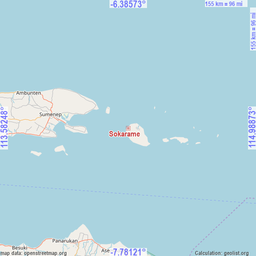
Sokarame GPS coordinates[2]
7° 5' 2.4" South, 114° 17' 8.16" East
| Map corner | latitude | longitude |
|---|---|---|
| Upper-left | -6.38573°, | 113.58248° |
| Center: | -7.084°, | 114.2856° |
| Lower-right: | -7.78121°, | 114.98873° |
| Map W x H: | 155.2×155.2 km | = 96.4×96.4mi |
| max Lat: | 5.88969° ⇑39.1% North |
| Sokarame: | -7.084° |
| min Lat: | ⇓60.9% South -10.934° |
| min Long | Sokarame | max Long |
| 95.1345° | 114.2856° | 140.9419° |
| W 68.9%⇐ | ⇒31.1% E |
Elevation
Elevation of Sokarame is 27 m = 89 ft, and this is 202.7 m = 665 ft below average elevation for this country.
| Max E: |
3185 m = 10449 ft | 73.4% |
| Avg. | 229.7 m = 754 ft | |
| Sokarame | 27 m = 89 ft | |
Min E: |
-1 m = -3 ft | 26.6% |
See also: Indonesia elevation on elevation.city.
Geographical zone
Sokarame is located in South Torrid zone (between Equator and Tropic of Capricorn). Distance of Equator is 787.7 km =489.5 mi to North.| Distance of | km | miles | from Sokarame |
|---|---|---|---|
| Equator | 787.7 | 489.5 | to North |
| Tropic Capricorn | 1818.3 | 1129.8 | to South |
| Antarctic Circle | 6613.5 | 4109.4 | to South |
| South Pole | 9219.4 | 5728.7 | to South |


Nearby cities:
15 places around Sokarame: (largest is in red/bold)
• Daleman
4.2 km =2.6 mi,  102°
102°
• Gayam
10.2 km =6.3 mi,  150°
150°
• Guder Lao
7.7 km =4.8 mi,  143°
143°
• Jambuir Timur
9.1 km =5.7 mi, 147°
• Kemuning
5.6 km =3.5 mi, 100°
• Kengkang
8.6 km =5.3 mi,  133°
133°
• Klebu
6.3 km =3.9 mi,  159°
159°
• Koatas Lao
10.5 km =6.5 mi, 128°
• Nonggunong
7.1 km =4.4 mi,  80°
80°
• Pocok
8.8 km =5.5 mi, 100°
• Prengbatu
9.4 km =5.8 mi, 136°
• Rosong Timur
6.9 km =4.3 mi,  72°
72°
• Talaga
5.1 km =3.2 mi,  60°
60°
• Tanamera
5.7 km =3.5 mi, 82°
• Tarebung
1.8 km =1.1 mi,  233°
233°
Sources, notices
• [Note1] Compared only with cities in Indonesia existing in our database
• [Src1] Map data: © OpenStreetMap contributors (CC-BY-SA)
• [Src2] Other city data from geonames.org with taken over terms of usage.
• [Src3] Geographical zone / Annual Mean Temperature by Robert A. Rohde @ Wikipedia
