Plandi geodata
Plandi (East Java) is a seat of a fourth-order administrative division; located in Indonesia in Asia/Jakarta (GMT+7) time zone. In our database, there are 407 cities with bigger population. Compared to other cities in Indonesia, 66.2% of cities are located further ↑North; 55.2% of cities are located further ←West and 76.3% of cities have lower elevation than Plandi. Note1


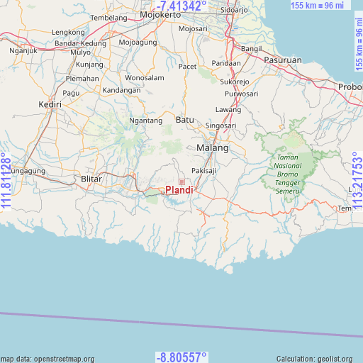
Plandi GPS coordinates[2]
8° 6' 36.36" South, 112° 30' 51.84" East
| Map corner | latitude | longitude |
|---|---|---|
| Upper-left | -7.41342°, | 111.81128° |
| Center: | -8.1101°, | 112.5144° |
| Lower-right: | -8.80557°, | 113.21753° |
| Map W x H: | 154.8×154.8 km | = 96.2×96.2mi |
| max Lat: | 5.88969° ⇑66.2% North |
| Plandi: | -8.1101° |
| min Lat: | ⇓33.8% South -10.934° |
| min Long | Plandi | max Long |
| 95.1345° | 112.5144° | 140.9419° |
| W 55.2%⇐ | ⇒44.8% E |
Elevation
Elevation of Plandi is 377 m = 1237 ft, and this is 147.3 m = 483 ft above average elevation for this country.
| Max E: |
3185 m = 10449 ft | 23.7% |
| Plandi | 377 m 1237 ft | |
| Avg. | 229.7 m = 754 ft | |
Min E: |
-1 m = -3 ft | 76.3% |
See also: Indonesia elevation on elevation.city.
Geographical zone
Plandi is located in South Torrid zone (between Equator and Tropic of Capricorn). Distance of Equator is 901.8 km =560.4 mi to North.| Distance of | km | miles | from Plandi |
|---|---|---|---|
| Equator | 901.8 | 560.4 | to North |
| Tropic Capricorn | 1704.2 | 1058.9 | to South |
| Antarctic Circle | 6499.4 | 4038.5 | to South |
| South Pole | 9105.3 | 5657.8 | to South |


Nearby cities:
15 places around Plandi: (largest is in red/bold)
• Bangelan
2 km =1.2 mi,  296°
296°
• Jatikerto
4 km =2.5 mi,  138°
138°
• Jatirejo
3.4 km =2.1 mi,  235°
235°
• Kertorejo
4.7 km =2.9 mi,  272°
272°
• Krandil
2.4 km =1.5 mi,  262°
262°
• Kromengan
3.4 km =2.1 mi,  229°
229°
• Maguan
5 km =3.1 mi,  29°
29°
• Ngasem
5.2 km =3.2 mi,  71°
71°
• Ngebruk
4.5 km =2.8 mi,  177°
177°
• Ngrejo
1.5 km =0.9 mi,  309°
309°
• Palaan
3.7 km =2.3 mi,  81°
81°
• Plaosan
2.1 km =1.3 mi,  9°
9°
• Selorok
4 km =2.5 mi,  161°
161°
• Talangagung
4.7 km =2.9 mi,  111°
111°
• Tumpangrejo
4.8 km =3 mi,  0°
0°
Sources, notices
• [Note1] Compared only with cities in Indonesia existing in our database
• [Src1] Map data: © OpenStreetMap contributors (CC-BY-SA)
• [Src2] Other city data from geonames.org with taken over terms of usage.
• [Src3] Geographical zone / Annual Mean Temperature by Robert A. Rohde @ Wikipedia
