Brongkal geodata
Brongkal (East Java) is a seat of a fourth-order administrative division; located in Indonesia in Asia/Jakarta (GMT+7) time zone. In our database, there are 407 cities with bigger population. Compared to other cities in Indonesia, 70.4% of cities are located further ↑North; 56% of cities are located further ←West and 72.7% of cities have lower elevation than Brongkal. Note1


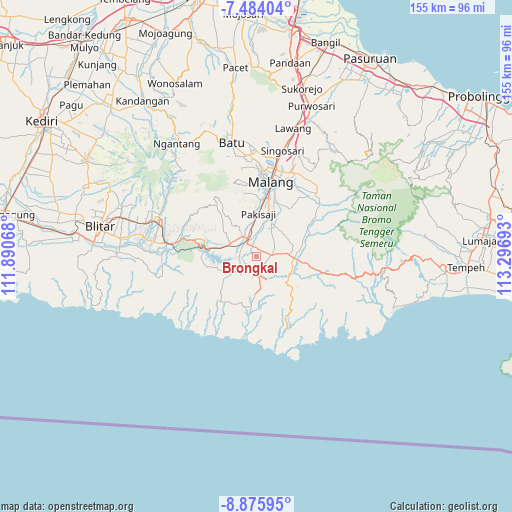
Brongkal GPS coordinates[2]
8° 10' 50.16" South, 112° 35' 37.68" East
| Map corner | latitude | longitude |
|---|---|---|
| Upper-left | -7.48404°, | 111.89068° |
| Center: | -8.1806°, | 112.5938° |
| Lower-right: | -8.87595°, | 113.29693° |
| Map W x H: | 154.8×154.8 km | = 96.2×96.2mi |
| max Lat: | 5.88969° ⇑70.4% North |
| Brongkal: | -8.1806° |
| min Lat: | ⇓29.6% South -10.934° |
| min Long | Brongkal | max Long |
| 95.1345° | 112.5938° | 140.9419° |
| W 56%⇐ | ⇒44% E |
Elevation
Elevation of Brongkal is 330 m = 1083 ft, and this is 100.3 m = 329 ft above average elevation for this country.
| Max E: |
3185 m = 10449 ft | 27.3% |
| Brongkal | 330 m 1083 ft | |
| Avg. | 229.7 m = 754 ft | |
Min E: |
-1 m = -3 ft | 72.7% |
See also: Indonesia elevation on elevation.city.
Geographical zone
Brongkal is located in South Torrid zone (between Equator and Tropic of Capricorn). Distance of Equator is 909.6 km =565.2 mi to North.| Distance of | km | miles | from Brongkal |
|---|---|---|---|
| Equator | 909.6 | 565.2 | to North |
| Tropic Capricorn | 1696.3 | 1054 | to South |
| Antarctic Circle | 6491.6 | 4033.7 | to South |
| South Pole | 9097.5 | 5652.9 | to South |


Nearby cities:
15 places around Brongkal: (largest is in red/bold)
• Balearjo
2.7 km =1.7 mi,  231°
231°
• Banjarejokrajan
3.4 km =2.1 mi,  92°
92°
• Ganjaran
4.9 km =3 mi,  27°
27°
• Gongdanglegi Kulon
4.7 km =2.9 mi,  82°
82°
• Kademangan
3.8 km =2.4 mi,  171°
171°
• Kanigorokrajan
1.7 km =1.1 mi,  252°
252°
• Karangsuko
1.7 km =1.1 mi,  20°
20°
• Kedungkrajan
3.9 km =2.4 mi,  341°
341°
• Pagelaran
3.5 km =2.2 mi,  122°
122°
• Panggungrejo
4 km =2.5 mi,  11°
11°
• Rejoyoso
4.4 km =2.7 mi,  203°
203°
• Sengguruhkrajan
4.9 km =3 mi,  280°
280°
• Sukosarikrajan
2.4 km =1.5 mi, 19°
• Suwaru
3.9 km =2.4 mi,  155°
155°
• Tegalsari
2.6 km =1.6 mi,  312°
312°
Sources, notices
• [Note1] Compared only with cities in Indonesia existing in our database
• [Src1] Map data: © OpenStreetMap contributors (CC-BY-SA)
• [Src2] Other city data from geonames.org with taken over terms of usage.
• [Src3] Geographical zone / Annual Mean Temperature by Robert A. Rohde @ Wikipedia
