Baraka geodata
Baraka (South Sulawesi) is a seat of a third-order administrative division; located in Indonesia in Asia/Makassar (GMT+8) time zone. In our database, there are 407 cities with bigger population. Compared to other cities in Indonesia, 90.5% of cities are located further ↓South; 82.4% of cities are located further ←West and 82.1% of cities have lower elevation than Baraka. Note1


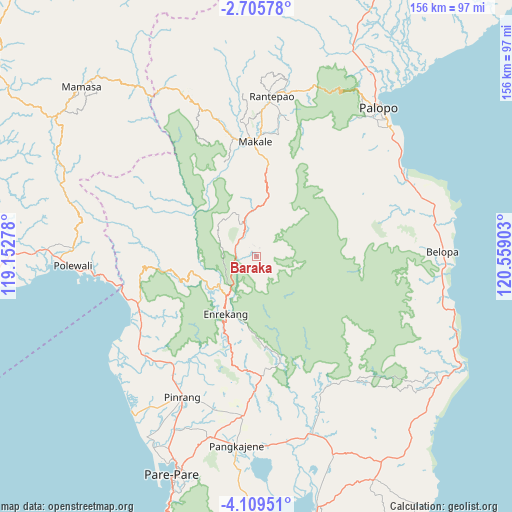
Baraka GPS coordinates[2]
3° 24' 28.44" South, 119° 51' 21.24" East
| Map corner | latitude | longitude |
|---|---|---|
| Upper-left | -2.70578°, | 119.15278° |
| Center: | -3.4079°, | 119.8559° |
| Lower-right: | -4.10951°, | 120.55903° |
| Map W x H: | 156.1×156.1 km | = 97×97mi |
| max Lat: | 5.88969° ⇑9.5% North |
| Baraka: | -3.4079° |
| min Lat: | ⇓90.5% South -10.934° |
| min Long | Baraka | max Long |
| 95.1345° | 119.8559° | 140.9419° |
| W 82.4%⇐ | ⇒17.6% E |
Elevation
Elevation of Baraka is 465 m = 1526 ft, and this is 235.3 m = 772 ft above average elevation for this country.
| Max E: |
3185 m = 10449 ft | 17.9% |
| Baraka | 465 m 1526 ft | |
| Avg. | 229.7 m = 754 ft | |
Min E: |
-1 m = -3 ft | 82.1% |
See also: Indonesia elevation on elevation.city.
Geographical zone
Baraka is located in South Torrid zone (between Equator and Tropic of Capricorn). Distance of Equator is 378.9 km =235.4 mi to North.| Distance of | km | miles | from Baraka |
|---|---|---|---|
| Equator | 378.9 | 235.4 | to North |
| Tropic Capricorn | 2227 | 1383.8 | to South |
| Antarctic Circle | 7022.3 | 4363.5 | to South |
| South Pole | 9628.1 | 5982.6 | to South |


Nearby cities:
15 places around Baraka: (largest is in red/bold)
• Baranti
48.7 km =30.3 mi,  189°
189°
• Belajen
10 km =6.2 mi,  339°
339°
• Beuma
30.9 km =19.2 mi,  45°
45°
• Buakayu
27.5 km =17.1 mi,  327°
327°
• Cakke
6.4 km =4 mi,  267°
267°
• Cempa Pasar
48.4 km =30.1 mi,  218°
218°
• Enrekang
19.9 km =12.4 mi,  208°
208°
• Getengan
25.4 km =15.8 mi,  7°
7°
• Lampa
45.7 km =28.4 mi,  231°
231°
• Makale
34 km =21.1 mi,  359°
359°
• Pinrang
47.7 km =29.6 mi, 208°
• Rappang
48.7 km =30.3 mi, 185°
• Tangratte
41.1 km =25.5 mi,  345°
345°
• Teppo
39.1 km =24.3 mi, 211°
• Totumbang
37.4 km =23.2 mi, 11°
Sources, notices
• [Note1] Compared only with cities in Indonesia existing in our database
• [Src1] Map data: © OpenStreetMap contributors (CC-BY-SA)
• [Src2] Other city data from geonames.org with taken over terms of usage.
• [Src3] Geographical zone / Annual Mean Temperature by Robert A. Rohde @ Wikipedia
