Getengan geodata
Getengan (South Sulawesi) is a seat of a third-order administrative division; located in Indonesia in Asia/Makassar (GMT+8) time zone. In our database, there are 407 cities with bigger population. Compared to other cities in Indonesia, 90.9% of cities are located further ↓South; 82.4% of cities are located further ←West and 98.1% of cities have lower elevation than Getengan. Note1


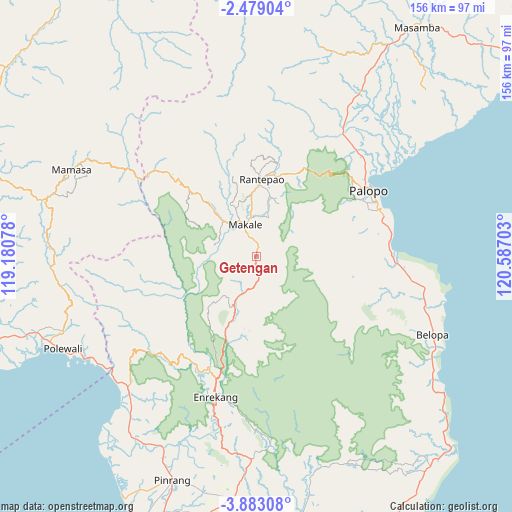
Getengan GPS coordinates[2]
3° 10' 52.68" South, 119° 53' 2.04" East
| Map corner | latitude | longitude |
|---|---|---|
| Upper-left | -2.47904°, | 119.18078° |
| Center: | -3.1813°, | 119.8839° |
| Lower-right: | -3.88308°, | 120.58703° |
| Map W x H: | 156.1×156.1 km | = 97×97mi |
| max Lat: | 5.88969° ⇑9.1% North |
| Getengan: | -3.1813° |
| min Lat: | ⇓90.9% South -10.934° |
| min Long | Getengan | max Long |
| 95.1345° | 119.8839° | 140.9419° |
| W 82.4%⇐ | ⇒17.6% E |
Elevation
Elevation of Getengan is 1040 m = 3412 ft, and this is 810.3 m = 2658 ft above average elevation for this country.
| Max E: |
3185 m = 10449 ft | 1.9% |
| Getengan | 1040 m 3412 ft | |
| Avg. | 229.7 m = 754 ft | |
Min E: |
-1 m = -3 ft | 98.1% |
See also: Indonesia elevation on elevation.city.
Geographical zone
Getengan is located in South Torrid zone (between Equator and Tropic of Capricorn). Distance of Equator is 353.7 km =219.8 mi to North.| Distance of | km | miles | from Getengan |
|---|---|---|---|
| Equator | 353.7 | 219.8 | to North |
| Tropic Capricorn | 2252.2 | 1399.5 | to South |
| Antarctic Circle | 7047.4 | 4379 | to South |
| South Pole | 9653.3 | 5998.3 | to South |


Nearby cities:
15 places around Getengan: (largest is in red/bold)
• Baraka
25.4 km =15.8 mi,  187°
187°
• Batuputih
41.3 km =25.7 mi,  53°
53°
• Belajen
17.2 km =10.7 mi,  202°
202°
• Beringinjaya
40.6 km =25.2 mi,  61°
61°
• Beuma
19 km =11.8 mi,  100°
100°
• Buakayu
18 km =11.2 mi,  263°
263°
• Cakke
27.1 km =16.8 mi, 200°
• Enrekang
44.5 km =27.7 mi, 196°
• Makale
9.4 km =5.8 mi,  339°
339°
• Palopo
40.6 km =25.2 mi, 58°
• Rantepang
29.2 km =18.1 mi,  12°
12°
• Rantepao
23.5 km =14.6 mi,  3°
3°
• Rindingallo
32.5 km =20.2 mi,  346°
346°
• Tangratte
19.8 km =12.3 mi,  317°
317°
• Totumbang
12.2 km =7.6 mi,  19°
19°
Sources, notices
• [Note1] Compared only with cities in Indonesia existing in our database
• [Src1] Map data: © OpenStreetMap contributors (CC-BY-SA)
• [Src2] Other city data from geonames.org with taken over terms of usage.
• [Src3] Geographical zone / Annual Mean Temperature by Robert A. Rohde @ Wikipedia
