Rappang geodata
Rappang (South Sulawesi) is a seat of a third-order administrative division; located in Indonesia in Asia/Makassar (GMT+8) time zone. In our database, there are 407 cities with bigger population. Compared to other cities in Indonesia, 89.7% of cities are located further ↓South; 82.3% of cities are located further ←West and 67.4% of cities have higher elevation than Rappang. Note1


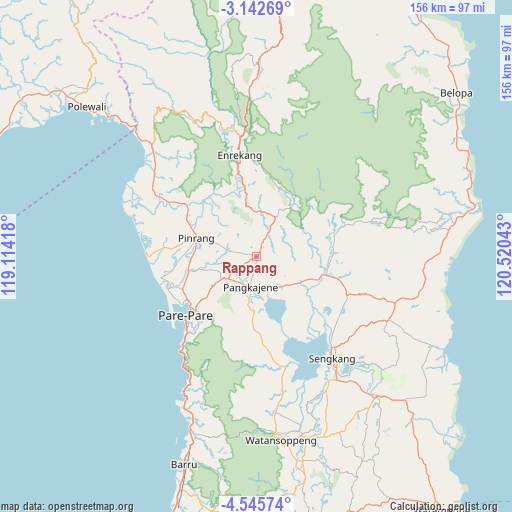
Rappang GPS coordinates[2]
3° 50' 40.2" South, 119° 49' 2.28" East
| Map corner | latitude | longitude |
|---|---|---|
| Upper-left | -3.14269°, | 119.11418° |
| Center: | -3.8445°, | 119.8173° |
| Lower-right: | -4.54574°, | 120.52043° |
| Map W x H: | 156×156 km | = 96.9×96.9mi |
| max Lat: | 5.88969° ⇑10.3% North |
| Rappang: | -3.8445° |
| min Lat: | ⇓89.7% South -10.934° |
| min Long | Rappang | max Long |
| 95.1345° | 119.8173° | 140.9419° |
| W 82.3%⇐ | ⇒17.7% E |
Elevation
Elevation of Rappang is 37 m = 121 ft, and this is 192.7 m = 632 ft below average elevation for this country.
| Max E: |
3185 m = 10449 ft | 67.4% |
| Avg. | 229.7 m = 754 ft | |
| Rappang | 37 m = 121 ft | |
Min E: |
-1 m = -3 ft | 32.6% |
See also: Indonesia elevation on elevation.city.
Geographical zone
Rappang is located in South Torrid zone (between Equator and Tropic of Capricorn). Distance of Equator is 427.5 km =265.6 mi to North.| Distance of | km | miles | from Rappang |
|---|---|---|---|
| Equator | 427.5 | 265.6 | to North |
| Tropic Capricorn | 2178.5 | 1353.7 | to South |
| Antarctic Circle | 6973.7 | 4333.3 | to South |
| South Pole | 9579.6 | 5952.5 | to South |


Nearby cities:
15 places around Rappang: (largest is in red/bold)
• Amparita
16.6 km =10.3 mi,  181°
181°
• Baranti
3.8 km =2.4 mi,  278°
278°
• Cempa Pasar
28 km =17.4 mi,  292°
292°
• Enrekang
31.5 km =19.6 mi,  350°
350°
• Harapankarya
25.1 km =15.6 mi,  230°
230°
• Lampa
37.4 km =23.2 mi,  302°
302°
• Langnga
32.7 km =20.3 mi,  269°
269°
• Majennang
27.1 km =16.8 mi,  238°
238°
• Parepare
28.4 km =17.6 mi, 228°
• Pinrang
19.4 km =12.1 mi, 289°
• Sengkang
39.3 km =24.4 mi,  143°
143°
• Sidenreng
9.4 km =5.8 mi,  192°
192°
• Tancung
32.9 km =20.4 mi,  134°
134°
• Teppo
22.4 km =13.9 mi,  313°
313°
• Uluale
10.7 km =6.6 mi, 229°
Sources, notices
• [Note1] Compared only with cities in Indonesia existing in our database
• [Src1] Map data: © OpenStreetMap contributors (CC-BY-SA)
• [Src2] Other city data from geonames.org with taken over terms of usage.
• [Src3] Geographical zone / Annual Mean Temperature by Robert A. Rohde @ Wikipedia
