Olafulihaa geodata
Olafulihaa (East Nusa Tenggara) is a seat of a third-order administrative division; located in Indonesia in Asia/Makassar (GMT+8) time zone. In our database, there are 407 cities with bigger population. Compared to other cities in Indonesia, 99.4% of cities are located further ↑North; 91.3% of cities are located further ←West and 55.9% of cities have higher elevation than Olafulihaa. Note1


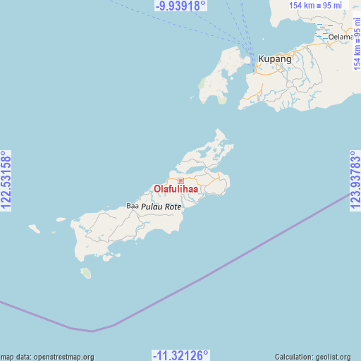
Olafulihaa GPS coordinates[2]
10° 37' 51.6" South, 123° 14' 4.92" East
| Map corner | latitude | longitude |
|---|---|---|
| Upper-left | -9.93918°, | 122.53158° |
| Center: | -10.631°, | 123.2347° |
| Lower-right: | -11.32126°, | 123.93783° |
| Map W x H: | 153.7×153.7 km | = 95.5×95.5mi |
| max Lat: | 5.88969° ⇑99.4% North |
| Olafulihaa: | -10.631° |
| min Lat: | ⇓0.6% South -10.934° |
| min Long | Olafulihaa | max Long |
| 95.1345° | 123.2347° | 140.9419° |
| W 91.3%⇐ | ⇒8.7% E |
Elevation
Elevation of Olafulihaa is 79 m = 259 ft, and this is 150.7 m = 494 ft below average elevation for this country.
| Max E: |
3185 m = 10449 ft | 55.9% |
| Avg. | 229.7 m = 754 ft | |
| Olafulihaa | 79 m = 259 ft | |
Min E: |
-1 m = -3 ft | 44.1% |
See also: Indonesia elevation on elevation.city.
Geographical zone
Olafulihaa is located in South Torrid zone (between Equator and Tropic of Capricorn). Distance of Equator is 1182.1 km =734.5 mi to North.| Distance of | km | miles | from Olafulihaa |
|---|---|---|---|
| Equator | 1182.1 | 734.5 | to North |
| Tropic Capricorn | 1423.9 | 884.8 | to South |
| Antarctic Circle | 6219.1 | 3864.4 | to South |
| South Pole | 8825 | 5483.6 | to South |


Nearby cities:
15 places around Olafulihaa: (largest is in red/bold)
• Batulilok Satu
11.7 km =7.3 mi,  175°
175°
• Bebengu
11.2 km =7 mi,  131°
131°
• Biuk
3.9 km =2.4 mi,  322°
322°
• Daeosin Satu
4.2 km =2.6 mi,  279°
279°
• Kakaek
11.5 km =7.1 mi,  167°
167°
• Karafao
6.1 km =3.8 mi,  25°
25°
• Kenamoen
11.5 km =7.1 mi, 29°
• Keoen Satu
6.8 km =4.2 mi,  72°
72°
• Kolla
8.9 km =5.5 mi,  250°
250°
• Momanalu
10.8 km =6.7 mi, 250°
• Nesubatu
10.6 km =6.6 mi,  101°
101°
• Nitanggoeng
11.9 km =7.4 mi,  220°
220°
• Oesuti Dua
8.3 km =5.2 mi,  78°
78°
• Puan Selatan
11.1 km =6.9 mi,  146°
146°
• Sua
3.4 km =2.1 mi, 70°
Sources, notices
• [Note1] Compared only with cities in Indonesia existing in our database
• [Src1] Map data: © OpenStreetMap contributors (CC-BY-SA)
• [Src2] Other city data from geonames.org with taken over terms of usage.
• [Src3] Geographical zone / Annual Mean Temperature by Robert A. Rohde @ Wikipedia
