Lancar geodata
Lancar (Central Java) is a seat of a fourth-order administrative division; located in Indonesia in Asia/Jakarta (GMT+7) time zone. In our database, there are 407 cities with bigger population. Compared to other cities in Indonesia, 57.9% of cities are located further ↑North; 66.5% of cities are located further →East and 84.2% of cities have higher elevation than Lancar. Note1


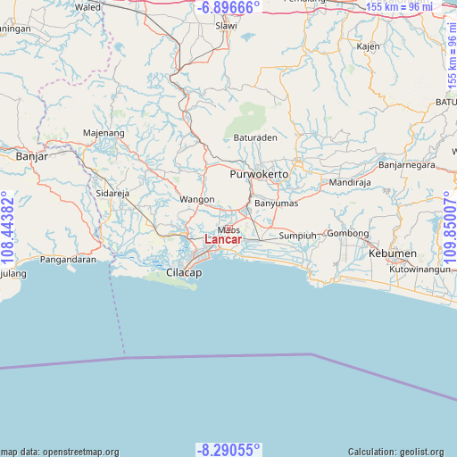
Lancar GPS coordinates[2]
7° 35' 39.012" South, 109° 8' 48.984" East
| Map corner | latitude | longitude |
|---|---|---|
| Upper-left | -6.89666°, | 108.44382° |
| Center: | -7.59417°, | 109.14694° |
| Lower-right: | -8.29055°, | 109.85007° |
| Map W x H: | 155×155 km | = 96.3×96.3mi |
| max Lat: | 5.88969° ⇑57.9% North |
| Lancar: | -7.59417° |
| min Lat: | ⇓42.1% South -10.934° |
| min Long | Lancar | max Long |
| 95.1345° | 109.14694° | 140.9419° |
| W 33.5%⇐ | ⇒66.5% E |
Elevation
Elevation of Lancar is 15 m = 49 ft, and this is 214.7 m = 704 ft below average elevation for this country.
| Max E: |
3185 m = 10449 ft | 84.2% |
| Avg. | 229.7 m = 754 ft | |
| Lancar | 15 m = 49 ft | |
Min E: |
-1 m = -3 ft | 15.8% |
See also: Indonesia elevation on elevation.city.
Geographical zone
Lancar is located in South Torrid zone (between Equator and Tropic of Capricorn). Distance of Equator is 844.4 km =524.7 mi to North.| Distance of | km | miles | from Lancar |
|---|---|---|---|
| Equator | 844.4 | 524.7 | to North |
| Tropic Capricorn | 1761.5 | 1094.5 | to South |
| Antarctic Circle | 6556.8 | 4074.2 | to South |
| South Pole | 9162.7 | 5693.4 | to South |


Nearby cities:
15 places around Lancar: (largest is in red/bold)
• Brani
5.2 km =3.2 mi,  40°
40°
• Bulupayung
0.9 km =0.6 mi,  252°
252°
• Glempang Tengah
2.7 km =1.7 mi,  52°
52°
• Karanglewas
4.6 km =2.9 mi,  348°
348°
• Karangrena
2.5 km =1.6 mi,  234°
234°
• Keleng
3.9 km =2.4 mi,  268°
268°
• Kesugihan
3.8 km =2.4 mi, 227°
• Klapagada
3.2 km =2 mi,  176°
176°
• Krikil
3.4 km =2.1 mi, 180°
• Losari
4.1 km =2.5 mi,  11°
11°
• Menganti
5.1 km =3.2 mi, 11°
• Mernek
4.2 km =2.6 mi,  119°
119°
• Pekuncen
4.9 km =3 mi,  320°
320°
• Penisihan
1.5 km =0.9 mi,  58°
58°
• Watuagung
3.5 km =2.2 mi, 269°
Sources, notices
• [Note1] Compared only with cities in Indonesia existing in our database
• [Src1] Map data: © OpenStreetMap contributors (CC-BY-SA)
• [Src2] Other city data from geonames.org with taken over terms of usage.
• [Src3] Geographical zone / Annual Mean Temperature by Robert A. Rohde @ Wikipedia
