Losari geodata
Losari (Central Java) is a seat of a fourth-order administrative division; located in Indonesia in Asia/Jakarta (GMT+7) time zone. In our database, there are 407 cities with bigger population. Compared to other cities in Indonesia, 57.3% of cities are located further ↑North; 66.5% of cities are located further →East and 81.9% of cities have higher elevation than Losari. Note1


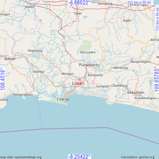
Losari GPS coordinates[2]
7° 33' 28.008" South, 109° 9' 16.992" East
| Map corner | latitude | longitude |
|---|---|---|
| Upper-left | -6.86022°, | 108.4516° |
| Center: | -7.55778°, | 109.15472° |
| Lower-right: | -8.25422°, | 109.85785° |
| Map W x H: | 155×155 km | = 96.3×96.3mi |
| max Lat: | 5.88969° ⇑57.3% North |
| Losari: | -7.55778° |
| min Lat: | ⇓42.7% South -10.934° |
| min Long | Losari | max Long |
| 95.1345° | 109.15472° | 140.9419° |
| W 33.5%⇐ | ⇒66.5% E |
Elevation
Elevation of Losari is 17 m = 56 ft, and this is 212.7 m = 698 ft below average elevation for this country.
| Max E: |
3185 m = 10449 ft | 81.9% |
| Avg. | 229.7 m = 754 ft | |
| Losari | 17 m = 56 ft | |
Min E: |
-1 m = -3 ft | 18.1% |
See also: Indonesia elevation on elevation.city.
Geographical zone
Losari is located in South Torrid zone (between Equator and Tropic of Capricorn). Distance of Equator is 840.3 km =522.1 mi to North.| Distance of | km | miles | from Losari |
|---|---|---|---|
| Equator | 840.3 | 522.1 | to North |
| Tropic Capricorn | 1765.6 | 1097.1 | to South |
| Antarctic Circle | 6560.8 | 4076.7 | to South |
| South Pole | 9166.7 | 5695.9 | to South |


Nearby cities:
15 places around Losari: (largest is in red/bold)
• Brani
2.5 km =1.6 mi,  92°
92°
• Gambarjati
3.7 km =2.3 mi,  309°
309°
• Glempang Tengah
2.7 km =1.7 mi,  152°
152°
• Jatilawang
4.6 km =2.9 mi,  303°
303°
• Karanglewas
1.8 km =1.1 mi,  284°
284°
• Karangtengah
3.9 km =2.4 mi,  102°
102°
• Lancar
4.1 km =2.5 mi,  191°
191°
• Margasana
2.8 km =1.7 mi,  320°
320°
• Menganti
1 km =0.6 mi,  10°
10°
• Pekuncen
4 km =2.5 mi,  266°
266°
• Penisihan
3.3 km =2.1 mi,  171°
171°
• Pesawahan
4 km =2.5 mi,  21°
21°
• Rawalo
3.6 km =2.2 mi,  49°
49°
• Sampang
4.7 km =2.9 mi, 97°
• Tengah
4.6 km =2.9 mi, 273°
Sources, notices
• [Note1] Compared only with cities in Indonesia existing in our database
• [Src1] Map data: © OpenStreetMap contributors (CC-BY-SA)
• [Src2] Other city data from geonames.org with taken over terms of usage.
• [Src3] Geographical zone / Annual Mean Temperature by Robert A. Rohde @ Wikipedia
