Menganti geodata
Menganti (Central Java) is a seat of a fourth-order administrative division; located in Indonesia in Asia/Jakarta (GMT+7) time zone. In our database, there are 407 cities with bigger population. Compared to other cities in Indonesia, 57.1% of cities are located further ↑North; 66.4% of cities are located further →East and 80.9% of cities have higher elevation than Menganti. Note1


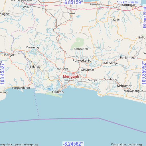
Menganti GPS coordinates[2]
7° 32' 57.012" South, 109° 9' 23.004" East
| Map corner | latitude | longitude |
|---|---|---|
| Upper-left | -6.85159°, | 108.45327° |
| Center: | -7.54917°, | 109.15639° |
| Lower-right: | -8.24562°, | 109.85952° |
| Map W x H: | 155×155 km | = 96.3×96.3mi |
| max Lat: | 5.88969° ⇑57.1% North |
| Menganti: | -7.54917° |
| min Lat: | ⇓42.9% South -10.934° |
| min Long | Menganti | max Long |
| 95.1345° | 109.15639° | 140.9419° |
| W 33.6%⇐ | ⇒66.4% E |
Elevation
Elevation of Menganti is 18 m = 59 ft, and this is 211.7 m = 695 ft below average elevation for this country.
| Max E: |
3185 m = 10449 ft | 80.9% |
| Avg. | 229.7 m = 754 ft | |
| Menganti | 18 m = 59 ft | |
Min E: |
-1 m = -3 ft | 19.1% |
See also: Indonesia elevation on elevation.city.
Geographical zone
Menganti is located in South Torrid zone (between Equator and Tropic of Capricorn). Distance of Equator is 839.4 km =521.6 mi to North.| Distance of | km | miles | from Menganti |
|---|---|---|---|
| Equator | 839.4 | 521.6 | to North |
| Tropic Capricorn | 1766.5 | 1097.7 | to South |
| Antarctic Circle | 6561.8 | 4077.3 | to South |
| South Pole | 9167.7 | 5696.5 | to South |


Nearby cities:
15 places around Menganti: (largest is in red/bold)
• Brani
2.6 km =1.6 mi,  114°
114°
• Gambarjati
3.3 km =2.1 mi,  294°
294°
• Glempang Tengah
3.6 km =2.2 mi,  162°
162°
• Jatilawang
4.4 km =2.7 mi, 292°
• Karanglewas
2 km =1.2 mi,  255°
255°
• Karangtengah
4.1 km =2.5 mi,  116°
116°
• Losari
1 km =0.6 mi,  190°
190°
• Margasana
2.3 km =1.4 mi,  301°
301°
• Pekuncen
4.3 km =2.7 mi,  254°
254°
• Penisihan
4.2 km =2.6 mi,  176°
176°
• Pesawahan
3.1 km =1.9 mi,  24°
24°
• Rawalo
2.9 km =1.8 mi,  61°
61°
• Sampang
4.7 km =2.9 mi, 109°
• Tinggarwangi
4.7 km =2.9 mi,  307°
307°
• Tugu
4.3 km =2.7 mi,  331°
331°
Sources, notices
• [Note1] Compared only with cities in Indonesia existing in our database
• [Src1] Map data: © OpenStreetMap contributors (CC-BY-SA)
• [Src2] Other city data from geonames.org with taken over terms of usage.
• [Src3] Geographical zone / Annual Mean Temperature by Robert A. Rohde @ Wikipedia
