Gununglaban geodata
Gununglaban (Central Java) is a seat of a fourth-order administrative division; located in Indonesia in Asia/Jakarta (GMT+7) time zone. In our database, there are 407 cities with bigger population. Compared to other cities in Indonesia, 57.9% of cities are located further ↑North; 66.2% of cities are located further →East and 89% of cities have higher elevation than Gununglaban. Note1


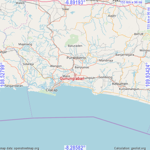
Gununglaban GPS coordinates[2]
7° 35' 21.984" South, 109° 13' 51.996" East
| Map corner | latitude | longitude |
|---|---|---|
| Upper-left | -6.89193°, | 108.52799° |
| Center: | -7.58944°, | 109.23111° |
| Lower-right: | -8.28582°, | 109.93424° |
| Map W x H: | 155×155 km | = 96.3×96.3mi |
| max Lat: | 5.88969° ⇑57.9% North |
| Gununglaban: | -7.58944° |
| min Lat: | ⇓42.1% South -10.934° |
| min Long | Gununglaban | max Long |
| 95.1345° | 109.23111° | 140.9419° |
| W 33.8%⇐ | ⇒66.2% E |
Elevation
Elevation of Gununglaban is 11 m = 36 ft, and this is 218.7 m = 718 ft below average elevation for this country.
| Max E: |
3185 m = 10449 ft | 89% |
| Avg. | 229.7 m = 754 ft | |
| Gununglaban | 11 m = 36 ft | |
Min E: |
-1 m = -3 ft | 11% |
See also: Indonesia elevation on elevation.city.
Geographical zone
Gununglaban is located in South Torrid zone (between Equator and Tropic of Capricorn). Distance of Equator is 843.9 km =524.4 mi to North.| Distance of | km | miles | from Gununglaban |
|---|---|---|---|
| Equator | 843.9 | 524.4 | to North |
| Tropic Capricorn | 1762.1 | 1094.9 | to South |
| Antarctic Circle | 6557.3 | 4074.5 | to South |
| South Pole | 9163.2 | 5693.7 | to South |


Nearby cities:
15 places around Gununglaban: (largest is in red/bold)
• Bayeman
1.9 km =1.2 mi,  222°
222°
• Binangun
6 km =3.7 mi,  16°
16°
• Brak
3.6 km =2.2 mi,  340°
340°
• Gambolempuk
2.4 km =1.5 mi,  2°
2°
• Kaliterus
5.3 km =3.3 mi, 223°
• Karangjati
1.2 km =0.7 mi,  316°
316°
• Karangtengah
5.3 km =3.3 mi,  300°
300°
• Ketanggung
3.8 km =2.4 mi,  247°
247°
• Kroya
5.1 km =3.2 mi,  161°
161°
• Mernek
6.2 km =3.9 mi, 245°
• Rawaseser
2.2 km =1.4 mi,  125°
125°
• Sampang
4.8 km =3 mi,  307°
307°
• Sampang Selatan
4.2 km =2.6 mi, 306°
• Sidasari
3.5 km =2.2 mi,  292°
292°
• Tinggarmalang
3.7 km =2.3 mi,  255°
255°
Sources, notices
• [Note1] Compared only with cities in Indonesia existing in our database
• [Src1] Map data: © OpenStreetMap contributors (CC-BY-SA)
• [Src2] Other city data from geonames.org with taken over terms of usage.
• [Src3] Geographical zone / Annual Mean Temperature by Robert A. Rohde @ Wikipedia
