Rawaseser geodata
Rawaseser (Central Java) is a seat of a fourth-order administrative division; located in Indonesia in Asia/Jakarta (GMT+7) time zone. In our database, there are 407 cities with bigger population. Compared to other cities in Indonesia, 58.1% of cities are located further ↑North; 66.1% of cities are located further →East and 87.7% of cities have higher elevation than Rawaseser. Note1


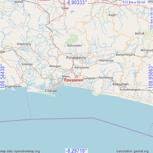
Rawaseser GPS coordinates[2]
7° 36' 2.988" South, 109° 14' 51" East
| Map corner | latitude | longitude |
|---|---|---|
| Upper-left | -6.90333°, | 108.54438° |
| Center: | -7.60083°, | 109.2475° |
| Lower-right: | -8.29719°, | 109.95063° |
| Map W x H: | 155×155 km | = 96.3×96.3mi |
| max Lat: | 5.88969° ⇑58.1% North |
| Rawaseser: | -7.60083° |
| min Lat: | ⇓41.9% South -10.934° |
| min Long | Rawaseser | max Long |
| 95.1345° | 109.2475° | 140.9419° |
| W 33.9%⇐ | ⇒66.1% E |
Elevation
Elevation of Rawaseser is 12 m = 39 ft, and this is 217.7 m = 714 ft below average elevation for this country.
| Max E: |
3185 m = 10449 ft | 87.7% |
| Avg. | 229.7 m = 754 ft | |
| Rawaseser | 12 m = 39 ft | |
Min E: |
-1 m = -3 ft | 12.3% |
See also: Indonesia elevation on elevation.city.
Geographical zone
Rawaseser is located in South Torrid zone (between Equator and Tropic of Capricorn). Distance of Equator is 845.1 km =525.1 mi to North.| Distance of | km | miles | from Rawaseser |
|---|---|---|---|
| Equator | 845.1 | 525.1 | to North |
| Tropic Capricorn | 1760.8 | 1094.1 | to South |
| Antarctic Circle | 6556 | 4073.7 | to South |
| South Pole | 9161.9 | 5692.9 | to South |


Nearby cities:
15 places around Rawaseser: (largest is in red/bold)
• Bayeman
3.1 km =1.9 mi,  268°
268°
• Binangun
7 km =4.3 mi,  359°
359°
• Brak
5.5 km =3.4 mi,  326°
326°
• Gambolempuk
4 km =2.5 mi,  335°
335°
• Gununglaban
2.2 km =1.4 mi,  305°
305°
• Kaliterus
6 km =3.7 mi,  244°
244°
• Karangjati
3.4 km =2.1 mi, 309°
• Karangtengah
7.5 km =4.7 mi,  301°
301°
• Ketanggung
5.3 km =3.3 mi, 268°
• Kroya
3.6 km =2.2 mi,  182°
182°
• Mernek
7.6 km =4.7 mi,  259°
259°
• Sampang
7 km =4.3 mi, 306°
• Sampang Selatan
6.4 km =4 mi, 305°
• Sidasari
5.7 km =3.5 mi, 297°
• Tinggarmalang
5.4 km =3.4 mi, 273°
Sources, notices
• [Note1] Compared only with cities in Indonesia existing in our database
• [Src1] Map data: © OpenStreetMap contributors (CC-BY-SA)
• [Src2] Other city data from geonames.org with taken over terms of usage.
• [Src3] Geographical zone / Annual Mean Temperature by Robert A. Rohde @ Wikipedia
