Kroya geodata
Kroya (Central Java) is a populated place; located in Indonesia in Asia/Jakarta (GMT+7) time zone. With population of 23,255 people, there are 362 cities with bigger population in this country. Compared to other cities in Indonesia, 58.6% of cities are located further ↑North; 66.1% of cities are located further →East and 80.9% of cities have higher elevation than Kroya. Note1


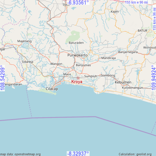
Kroya GPS coordinates[2]
7° 37' 59.016" South, 109° 14' 45.996" East
| Map corner | latitude | longitude |
|---|---|---|
| Upper-left | -6.93561°, | 108.54299° |
| Center: | -7.63306°, | 109.24611° |
| Lower-right: | -8.32937°, | 109.94924° |
| Map W x H: | 155×155 km | = 96.3×96.3mi |
| max Lat: | 5.88969° ⇑58.6% North |
| Kroya: | -7.63306° |
| min Lat: | ⇓41.4% South -10.934° |
| min Long | Kroya | max Long |
| 95.1345° | 109.24611° | 140.9419° |
| W 33.9%⇐ | ⇒66.1% E |
Elevation
Elevation of Kroya is 18 m = 59 ft, and this is 211.7 m = 695 ft below average elevation for this country.
| Max E: |
3185 m = 10449 ft | 80.9% |
| Avg. | 229.7 m = 754 ft | |
| Kroya | 18 m = 59 ft | |
Min E: |
-1 m = -3 ft | 19.1% |
See also: Indonesia elevation on elevation.city.
Geographical zone
Kroya is located in South Torrid zone (between Equator and Tropic of Capricorn). Distance of Equator is 848.7 km =527.4 mi to North.| Distance of | km | miles | from Kroya |
|---|---|---|---|
| Equator | 848.7 | 527.4 | to North |
| Tropic Capricorn | 1757.2 | 1091.9 | to South |
| Antarctic Circle | 6552.5 | 4071.5 | to South |
| South Pole | 9158.3 | 5690.7 | to South |


Nearby cities:
15 places around Kroya: (largest is in red/bold)
• Bayeman
4.5 km =2.8 mi,  320°
320°
• Binangun
10.6 km =6.6 mi,  0°
0°
• Brak
8.7 km =5.4 mi,  340°
340°
• Gambolempuk
7.4 km =4.6 mi,  348°
348°
• Gununglaban
5.1 km =3.2 mi, 341°
• Kaliterus
5.4 km =3.4 mi,  280°
280°
• Karangjati
6.3 km =3.9 mi, 336°
• Karangtengah
9.8 km =6.1 mi, 320°
• Ketanggung
6.2 km =3.9 mi,  303°
303°
• Mernek
7.7 km =4.8 mi,  287°
287°
• Rawaseser
3.6 km =2.2 mi, 2°
• Sampang
9.5 km =5.9 mi, 324°
• Sampang Selatan
8.9 km =5.5 mi,  325°
325°
• Sidasari
7.9 km =4.9 mi, 321°
• Tinggarmalang
6.5 km =4 mi,  307°
307°
Sources, notices
• [Note1] Compared only with cities in Indonesia existing in our database
• [Src1] Map data: © OpenStreetMap contributors (CC-BY-SA)
• [Src2] Other city data from geonames.org with taken over terms of usage.
• [Src3] Geographical zone / Annual Mean Temperature by Robert A. Rohde @ Wikipedia
