Karangtalun Lor geodata
Karangtalun Lor (East Java) is a seat of a fourth-order administrative division; located in Indonesia in Asia/Jakarta (GMT+7) time zone. In our database, there are 407 cities with bigger population. Compared to other cities in Indonesia, 70.4% of cities are located further ↑North; 50.5% of cities are located further →East and 51% of cities have lower elevation than Karangtalun Lor. Note1


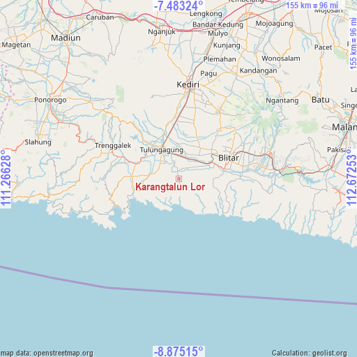
Karangtalun Lor GPS coordinates[2]
8° 10' 47.28" South, 111° 58' 9.84" East
| Map corner | latitude | longitude |
|---|---|---|
| Upper-left | -7.48324°, | 111.26628° |
| Center: | -8.1798°, | 111.9694° |
| Lower-right: | -8.87515°, | 112.67253° |
| Map W x H: | 154.8×154.8 km | = 96.2×96.2mi |
| max Lat: | 5.88969° ⇑70.4% North |
| Karangtalun Lor: | -8.1798° |
| min Lat: | ⇓29.6% South -10.934° |
| min Long | Karangtalun Lor | max Long |
| 95.1345° | 111.9694° | 140.9419° |
| W 49.5%⇐ | ⇒50.5% E |
Elevation
Elevation of Karangtalun Lor is 106 m = 348 ft, and this is 123.7 m = 406 ft below average elevation for this country.
| Max E: |
3185 m = 10449 ft | 49% |
| Avg. | 229.7 m = 754 ft | |
| Karangtalun Lor | 106 m = 348 ft | |
Min E: |
-1 m = -3 ft | 51% |
See also: Indonesia elevation on elevation.city.
Geographical zone
Karangtalun Lor is located in South Torrid zone (between Equator and Tropic of Capricorn). Distance of Equator is 909.5 km =565.1 mi to North.| Distance of | km | miles | from Karangtalun Lor |
|---|---|---|---|
| Equator | 909.5 | 565.1 | to North |
| Tropic Capricorn | 1696.4 | 1054.1 | to South |
| Antarctic Circle | 6491.7 | 4033.8 | to South |
| South Pole | 9097.6 | 5653 | to South |


Nearby cities:
15 places around Karangtalun Lor: (largest is in red/bold)
• Brandil
4.1 km =2.5 mi,  339°
339°
• Demuk
3.9 km =2.4 mi,  107°
107°
• Domasan
4 km =2.5 mi,  10°
10°
• Jabon
1.8 km =1.1 mi, 344°
• Kalidawir
0.3 km =0.2 mi, 109°
• Karangsonojabon
1.9 km =1.2 mi,  309°
309°
• Kedungdowo
2.7 km =1.7 mi,  166°
166°
• Manding
4 km =2.5 mi,  159°
159°
• Nganggrek
1.5 km =0.9 mi,  95°
95°
• Ngejring
1.8 km =1.1 mi,  296°
296°
• Ngluweng Dua
3.7 km =2.3 mi,  69°
69°
• Ngrejo
3 km =1.9 mi,  276°
276°
• Panggunguni
4.4 km =2.7 mi,  125°
125°
• Salakan Lor
3.7 km =2.3 mi,  46°
46°
• Tunggangri
3.4 km =2.1 mi,  353°
353°
Sources, notices
• [Note1] Compared only with cities in Indonesia existing in our database
• [Src1] Map data: © OpenStreetMap contributors (CC-BY-SA)
• [Src2] Other city data from geonames.org with taken over terms of usage.
• [Src3] Geographical zone / Annual Mean Temperature by Robert A. Rohde @ Wikipedia
