Panggunguni geodata
Panggunguni (East Java) is a seat of a fourth-order administrative division; located in Indonesia in Asia/Jakarta (GMT+7) time zone. In our database, there are 407 cities with bigger population. Compared to other cities in Indonesia, 71.7% of cities are located further ↑North; 50.1% of cities are located further ←West and 69.7% of cities have lower elevation than Panggunguni. Note1


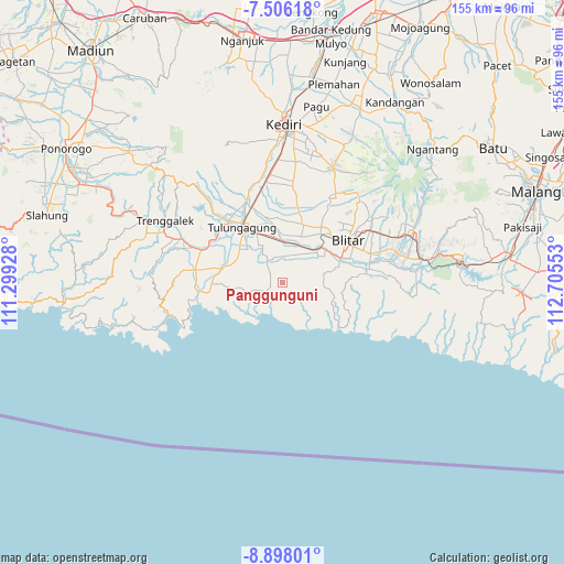
Panggunguni GPS coordinates[2]
8° 12' 9.72" South, 112° 0' 8.64" East
| Map corner | latitude | longitude |
|---|---|---|
| Upper-left | -7.50618°, | 111.29928° |
| Center: | -8.2027°, | 112.0024° |
| Lower-right: | -8.89801°, | 112.70553° |
| Map W x H: | 154.8×154.8 km | = 96.2×96.2mi |
| max Lat: | 5.88969° ⇑71.7% North |
| Panggunguni: | -8.2027° |
| min Lat: | ⇓28.3% South -10.934° |
| min Long | Panggunguni | max Long |
| 95.1345° | 112.0024° | 140.9419° |
| W 50.1%⇐ | ⇒49.9% E |
Elevation
Elevation of Panggunguni is 287 m = 942 ft, and this is 57.3 m = 188 ft above average elevation for this country.
| Max E: |
3185 m = 10449 ft | 30.3% |
| Panggunguni | 287 m 942 ft | |
| Avg. | 229.7 m = 754 ft | |
Min E: |
-1 m = -3 ft | 69.7% |
See also: Indonesia elevation on elevation.city.
Geographical zone
Panggunguni is located in South Torrid zone (between Equator and Tropic of Capricorn). Distance of Equator is 912.1 km =566.8 mi to North.| Distance of | km | miles | from Panggunguni |
|---|---|---|---|
| Equator | 912.1 | 566.8 | to North |
| Tropic Capricorn | 1693.9 | 1052.5 | to South |
| Antarctic Circle | 6489.1 | 4032.1 | to South |
| South Pole | 9095 | 5651.4 | to South |


Nearby cities:
15 places around Panggunguni: (largest is in red/bold)
• Demuk
1.4 km =0.9 mi,  5°
5°
• Kalidawir
4.1 km =2.5 mi,  306°
306°
• Kaligentong
3.2 km =2 mi,  205°
205°
• Karangsono
5.5 km =3.4 mi,  4°
4°
• Karangtalun Lor
4.4 km =2.7 mi, 305°
• Kedungdowo
3 km =1.9 mi,  269°
269°
• Manding
2.5 km =1.6 mi,  241°
241°
• Miribanteng
4.6 km =2.9 mi,  143°
143°
• Nganggrek
3.2 km =2 mi,  318°
318°
• Ngluweng Dua
3.8 km =2.4 mi,  357°
357°
• Panggungduwet
3.3 km =2.1 mi,  92°
92°
• Ruser
2.3 km =1.4 mi, 94°
• Salakan Lor
5.2 km =3.2 mi,  349°
349°
• Sumberbendo
3.2 km =2 mi,  161°
161°
• Tekik Wetan
5.6 km =3.5 mi, 243°
Sources, notices
• [Note1] Compared only with cities in Indonesia existing in our database
• [Src1] Map data: © OpenStreetMap contributors (CC-BY-SA)
• [Src2] Other city data from geonames.org with taken over terms of usage.
• [Src3] Geographical zone / Annual Mean Temperature by Robert A. Rohde @ Wikipedia
