Manding geodata
Manding (East Java) is a seat of a fourth-order administrative division; located in Indonesia in Asia/Jakarta (GMT+7) time zone. In our database, there are 407 cities with bigger population. Compared to other cities in Indonesia, 72.4% of cities are located further ↑North; 50.2% of cities are located further →East and 61.3% of cities have lower elevation than Manding. Note1


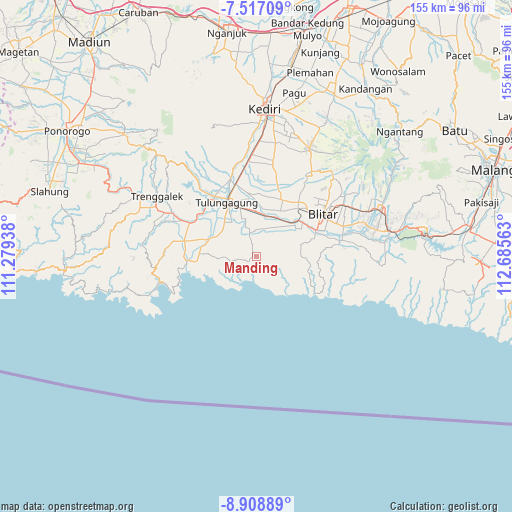
Manding GPS coordinates[2]
8° 12' 48.96" South, 111° 58' 57" East
| Map corner | latitude | longitude |
|---|---|---|
| Upper-left | -7.51709°, | 111.27938° |
| Center: | -8.2136°, | 111.9825° |
| Lower-right: | -8.90889°, | 112.68563° |
| Map W x H: | 154.8×154.8 km | = 96.2×96.2mi |
| max Lat: | 5.88969° ⇑72.4% North |
| Manding: | -8.2136° |
| min Lat: | ⇓27.6% South -10.934° |
| min Long | Manding | max Long |
| 95.1345° | 111.9825° | 140.9419° |
| W 49.8%⇐ | ⇒50.2% E |
Elevation
Elevation of Manding is 178 m = 584 ft, and this is 51.7 m = 170 ft below average elevation for this country.
| Max E: |
3185 m = 10449 ft | 38.7% |
| Avg. | 229.7 m = 754 ft | |
| Manding | 178 m = 584 ft | |
Min E: |
-1 m = -3 ft | 61.3% |
See also: Indonesia elevation on elevation.city.
Geographical zone
Manding is located in South Torrid zone (between Equator and Tropic of Capricorn). Distance of Equator is 913.3 km =567.5 mi to North.| Distance of | km | miles | from Manding |
|---|---|---|---|
| Equator | 913.3 | 567.5 | to North |
| Tropic Capricorn | 1692.7 | 1051.8 | to South |
| Antarctic Circle | 6487.9 | 4031.4 | to South |
| South Pole | 9093.8 | 5650.6 | to South |


Nearby cities:
15 places around Manding: (largest is in red/bold)
• Darungan
5 km =3.1 mi,  259°
259°
• Demuk
3.5 km =2.2 mi,  41°
41°
• Kalidawe
5.5 km =3.4 mi,  143°
143°
• Kalidawir
3.8 km =2.4 mi,  342°
342°
• Kaligentong
1.8 km =1.1 mi,  153°
153°
• Karangtalun Lor
4 km =2.5 mi, 339°
• Kedungdowo
1.4 km =0.9 mi,  325°
325°
• Miribanteng
5.5 km =3.4 mi,  116°
116°
• Nganggrek
3.6 km =2.2 mi,  0°
0°
• Ngluweng Dua
5.4 km =3.4 mi,  21°
21°
• Panggunguni
2.5 km =1.6 mi,  61°
61°
• Ruser
4.6 km =2.9 mi,  76°
76°
• Sumberbendo
3.7 km =2.3 mi, 119°
• Tekik Wetan
3.1 km =1.9 mi,  244°
244°
• Tekikbanyuurip
3.6 km =2.2 mi, 255°
Sources, notices
• [Note1] Compared only with cities in Indonesia existing in our database
• [Src1] Map data: © OpenStreetMap contributors (CC-BY-SA)
• [Src2] Other city data from geonames.org with taken over terms of usage.
• [Src3] Geographical zone / Annual Mean Temperature by Robert A. Rohde @ Wikipedia
