Tugu geodata
Tugu (East Java) is a seat of a fourth-order administrative division; located in Indonesia in Asia/Jakarta (GMT+7) time zone. In our database, there are 407 cities with bigger population. Compared to other cities in Indonesia, 67.9% of cities are located further ↑North; 50.3% of cities are located further ←West and 52.3% of cities have lower elevation than Tugu. Note1


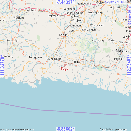
Tugu GPS coordinates[2]
8° 8' 26.16" South, 112° 1' 51.24" East
| Map corner | latitude | longitude |
|---|---|---|
| Upper-left | -7.44397°, | 111.32778° |
| Center: | -8.1406°, | 112.0309° |
| Lower-right: | -8.83602°, | 112.73403° |
| Map W x H: | 154.8×154.8 km | = 96.2×96.2mi |
| max Lat: | 5.88969° ⇑67.9% North |
| Tugu: | -8.1406° |
| min Lat: | ⇓32.1% South -10.934° |
| min Long | Tugu | max Long |
| 95.1345° | 112.0309° | 140.9419° |
| W 50.3%⇐ | ⇒49.7% E |
Elevation
Elevation of Tugu is 111 m = 364 ft, and this is 118.7 m = 389 ft below average elevation for this country.
| Max E: |
3185 m = 10449 ft | 47.7% |
| Avg. | 229.7 m = 754 ft | |
| Tugu | 111 m = 364 ft | |
Min E: |
-1 m = -3 ft | 52.3% |
See also: Indonesia elevation on elevation.city.
Geographical zone
Tugu is located in South Torrid zone (between Equator and Tropic of Capricorn). Distance of Equator is 905.1 km =562.4 mi to North.| Distance of | km | miles | from Tugu |
|---|---|---|---|
| Equator | 905.1 | 562.4 | to North |
| Tropic Capricorn | 1700.8 | 1056.8 | to South |
| Antarctic Circle | 6496 | 4036.4 | to South |
| South Pole | 9101.9 | 5655.7 | to South |


Nearby cities:
15 places around Tugu: (largest is in red/bold)
• Banjarsari Kidul
2.9 km =1.8 mi,  77°
77°
• Bendorubuh
3.1 km =1.9 mi,  275°
275°
• Jatidowo
2.2 km =1.4 mi,  115°
115°
• Karangsono
3.1 km =1.9 mi,  242°
242°
• Ngluweng Dua
4.5 km =2.8 mi,  227°
227°
• Ngunut
4.2 km =2.6 mi,  336°
336°
• Padangan
1.3 km =0.8 mi,  348°
348°
• Panjerrejo
1.5 km =0.9 mi, 280°
• Salakan Lor
4.5 km =2.8 mi,  246°
246°
• Samir
3.3 km =2.1 mi,  257°
257°
• Selorejo
4 km =2.5 mi,  273°
273°
• Sukorejo
2.7 km =1.7 mi,  133°
133°
• Tegalrejo
4 km =2.5 mi, 76°
• Tenggong
1.9 km =1.2 mi,  195°
195°
• Tenggur
1.9 km =1.2 mi,  60°
60°
Sources, notices
• [Note1] Compared only with cities in Indonesia existing in our database
• [Src1] Map data: © OpenStreetMap contributors (CC-BY-SA)
• [Src2] Other city data from geonames.org with taken over terms of usage.
• [Src3] Geographical zone / Annual Mean Temperature by Robert A. Rohde @ Wikipedia
