Ngrejo geodata
Ngrejo (East Java) is a seat of a fourth-order administrative division; located in Indonesia in Asia/Jakarta (GMT+7) time zone. In our database, there are 407 cities with bigger population. Compared to other cities in Indonesia, 73.7% of cities are located further ↑North; 50.8% of cities are located further ←West and 64% of cities have lower elevation than Ngrejo. Note1


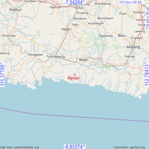
Ngrejo GPS coordinates[2]
8° 14' 18.6" South, 112° 4' 51.6" East
| Map corner | latitude | longitude |
|---|---|---|
| Upper-left | -7.54204°, | 111.37788° |
| Center: | -8.2385°, | 112.081° |
| Lower-right: | -8.93374°, | 112.78413° |
| Map W x H: | 154.7×154.7 km | = 96.1×96.1mi |
| max Lat: | 5.88969° ⇑73.7% North |
| Ngrejo: | -8.2385° |
| min Lat: | ⇓26.3% South -10.934° |
| min Long | Ngrejo | max Long |
| 95.1345° | 112.081° | 140.9419° |
| W 50.8%⇐ | ⇒49.2% E |
Elevation
Elevation of Ngrejo is 209 m = 686 ft, and this is 20.7 m = 68 ft below average elevation for this country.
| Max E: |
3185 m = 10449 ft | 36% |
| Avg. | 229.7 m = 754 ft | |
| Ngrejo | 209 m = 686 ft | |
Min E: |
-1 m = -3 ft | 64% |
See also: Indonesia elevation on elevation.city.
Geographical zone
Ngrejo is located in South Torrid zone (between Equator and Tropic of Capricorn). Distance of Equator is 916 km =569.2 mi to North.| Distance of | km | miles | from Ngrejo |
|---|---|---|---|
| Equator | 916 | 569.2 | to North |
| Tropic Capricorn | 1689.9 | 1050.1 | to South |
| Antarctic Circle | 6485.1 | 4029.7 | to South |
| South Pole | 9091 | 5648.9 | to South |


Nearby cities:
15 places around Ngrejo: (largest is in red/bold)
• Bakung
2.4 km =1.5 mi,  202°
202°
• Bakung Utara
2.1 km =1.3 mi,  214°
214°
• Bendosari
4 km =2.5 mi,  48°
48°
• Kalimeneng
5.2 km =3.2 mi,  168°
168°
• Kebonsari
4.4 km =2.7 mi,  343°
343°
• Kedungbanteng
1.3 km =0.8 mi,  88°
88°
• Kedunggajul
5.2 km =3.2 mi,  185°
185°
• Lorejo
4.2 km =2.6 mi,  82°
82°
• Maron
5.4 km =3.4 mi,  328°
328°
• Miribanteng
5.9 km =3.7 mi,  272°
272°
• Pakisaji
3.7 km =2.3 mi,  313°
313°
• Pasiraman
5.3 km =3.3 mi,  96°
96°
• Sumberdadi
3.2 km =2 mi,  216°
216°
• Suruhwadang
5.2 km =3.2 mi,  30°
30°
• Tumpakoyot
5.7 km =3.5 mi,  231°
231°
Sources, notices
• [Note1] Compared only with cities in Indonesia existing in our database
• [Src1] Map data: © OpenStreetMap contributors (CC-BY-SA)
• [Src2] Other city data from geonames.org with taken over terms of usage.
• [Src3] Geographical zone / Annual Mean Temperature by Robert A. Rohde @ Wikipedia
