Lorejo geodata
Lorejo (East Java) is a seat of a fourth-order administrative division; located in Indonesia in Asia/Jakarta (GMT+7) time zone. In our database, there are 407 cities with bigger population. Compared to other cities in Indonesia, 73.5% of cities are located further ↑North; 51% of cities are located further ←West and 70.5% of cities have lower elevation than Lorejo. Note1


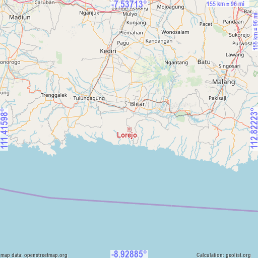
Lorejo GPS coordinates[2]
8° 14' 0.96" South, 112° 7' 8.76" East
| Map corner | latitude | longitude |
|---|---|---|
| Upper-left | -7.53713°, | 111.41598° |
| Center: | -8.2336°, | 112.1191° |
| Lower-right: | -8.92885°, | 112.82223° |
| Map W x H: | 154.7×154.7 km | = 96.1×96.1mi |
| max Lat: | 5.88969° ⇑73.5% North |
| Lorejo: | -8.2336° |
| min Lat: | ⇓26.5% South -10.934° |
| min Long | Lorejo | max Long |
| 95.1345° | 112.1191° | 140.9419° |
| W 51%⇐ | ⇒49% E |
Elevation
Elevation of Lorejo is 299 m = 981 ft, and this is 69.3 m = 227 ft above average elevation for this country.
| Max E: |
3185 m = 10449 ft | 29.5% |
| Lorejo | 299 m 981 ft | |
| Avg. | 229.7 m = 754 ft | |
Min E: |
-1 m = -3 ft | 70.5% |
See also: Indonesia elevation on elevation.city.
Geographical zone
Lorejo is located in South Torrid zone (between Equator and Tropic of Capricorn). Distance of Equator is 915.5 km =568.9 mi to North.| Distance of | km | miles | from Lorejo |
|---|---|---|---|
| Equator | 915.5 | 568.9 | to North |
| Tropic Capricorn | 1690.4 | 1050.4 | to South |
| Antarctic Circle | 6485.7 | 4030 | to South |
| South Pole | 9091.6 | 5649.3 | to South |


Nearby cities:
15 places around Lorejo: (largest is in red/bold)
• Bakung
5.8 km =3.6 mi,  241°
241°
• Bakung Utara
5.8 km =3.6 mi,  247°
247°
• Bendosari
2.4 km =1.5 mi,  329°
329°
• Gununggede
6 km =3.7 mi,  111°
111°
• Kaligrenjeng
4.6 km =2.9 mi,  166°
166°
• Kalimeneng
6.5 km =4 mi,  209°
209°
• Kebonsari
6.6 km =4.1 mi,  304°
304°
• Kedungbanteng
3 km =1.9 mi,  260°
260°
• Ngrejo
4.2 km =2.6 mi, 262°
• Pasiraman
1.5 km =0.9 mi,  136°
136°
• Sumberboto Satu
3.2 km =2 mi,  78°
78°
• Sumberjo
6.3 km =3.9 mi,  347°
347°
• Suruhwadang
4.2 km =2.6 mi,  338°
338°
• Tumpakkepuh
6.6 km =4.1 mi,  191°
191°
• Wonotirto
4 km =2.5 mi, 75°
Sources, notices
• [Note1] Compared only with cities in Indonesia existing in our database
• [Src1] Map data: © OpenStreetMap contributors (CC-BY-SA)
• [Src2] Other city data from geonames.org with taken over terms of usage.
• [Src3] Geographical zone / Annual Mean Temperature by Robert A. Rohde @ Wikipedia
