Krajan geodata
Krajan (East Java) is a seat of a fourth-order administrative division; located in Indonesia in Asia/Jakarta (GMT+7) time zone. In our database, there are 407 cities with bigger population. Compared to other cities in Indonesia, 67.5% of cities are located further ↑North; 53% of cities are located further ←West and 65.3% of cities have lower elevation than Krajan. Note1


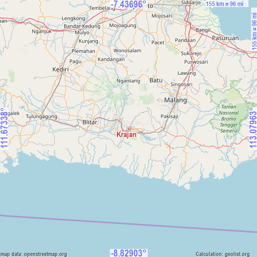
Krajan GPS coordinates[2]
8° 8' 0.96" South, 112° 22' 35.4" East
| Map corner | latitude | longitude |
|---|---|---|
| Upper-left | -7.43696°, | 111.67338° |
| Center: | -8.1336°, | 112.3765° |
| Lower-right: | -8.82903°, | 113.07963° |
| Map W x H: | 154.8×154.8 km | = 96.2×96.2mi |
| max Lat: | 5.88969° ⇑67.5% North |
| Krajan: | -8.1336° |
| min Lat: | ⇓32.5% South -10.934° |
| min Long | Krajan | max Long |
| 95.1345° | 112.3765° | 140.9419° |
| W 53%⇐ | ⇒47% E |
Elevation
Elevation of Krajan is 225 m = 738 ft, and this is 4.7 m = 15 ft below average elevation for this country.
| Max E: |
3185 m = 10449 ft | 34.7% |
| Avg. | 229.7 m = 754 ft | |
| Krajan | 225 m = 738 ft | |
Min E: |
-1 m = -3 ft | 65.3% |
See also: Indonesia elevation on elevation.city.
Geographical zone
Krajan is located in South Torrid zone (between Equator and Tropic of Capricorn). Distance of Equator is 904.4 km =562 mi to North.| Distance of | km | miles | from Krajan |
|---|---|---|---|
| Equator | 904.4 | 562 | to North |
| Tropic Capricorn | 1701.5 | 1057.3 | to South |
| Antarctic Circle | 6496.8 | 4036.9 | to South |
| South Pole | 9102.7 | 5656.2 | to South |


Nearby cities:
15 places around Krajan: (largest is in red/bold)
• Bukur
4.6 km =2.9 mi,  287°
287°
• Kesamben
1.8 km =1.1 mi,  220°
220°
• Ngadri
5.5 km =3.4 mi,  196°
196°
• Pakel
4.7 km =2.9 mi,  54°
54°
• Pohgajih
5.3 km =3.3 mi,  115°
115°
• Ringinrejo
5.7 km =3.5 mi,  11°
11°
• Selorejo
5.5 km =3.4 mi,  96°
96°
• Sembung
1.1 km =0.7 mi,  140°
140°
• Siraman
4.6 km =2.9 mi,  256°
256°
• Sukoanyar
1.9 km =1.2 mi,  109°
109°
• Suru
5.2 km =3.2 mi,  328°
328°
• Tapakrejo
3.9 km =2.4 mi, 45°
• Tepas
4.5 km =2.8 mi,  26°
26°
• Tulungrejo
3.9 km =2.4 mi,  309°
309°
• Umbuldamar
5.6 km =3.5 mi, 203°
Sources, notices
• [Note1] Compared only with cities in Indonesia existing in our database
• [Src1] Map data: © OpenStreetMap contributors (CC-BY-SA)
• [Src2] Other city data from geonames.org with taken over terms of usage.
• [Src3] Geographical zone / Annual Mean Temperature by Robert A. Rohde @ Wikipedia
