Umbuldamar geodata
Umbuldamar (East Java) is a seat of a fourth-order administrative division; located in Indonesia in Asia/Jakarta (GMT+7) time zone. In our database, there are 407 cities with bigger population. Compared to other cities in Indonesia, 70.3% of cities are located further ↑North; 52.9% of cities are located further ←West and 62.8% of cities have lower elevation than Umbuldamar. Note1


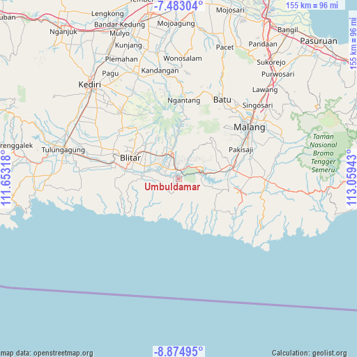
Umbuldamar GPS coordinates[2]
8° 10' 46.56" South, 112° 21' 22.68" East
| Map corner | latitude | longitude |
|---|---|---|
| Upper-left | -7.48304°, | 111.65318° |
| Center: | -8.1796°, | 112.3563° |
| Lower-right: | -8.87495°, | 113.05943° |
| Map W x H: | 154.8×154.8 km | = 96.2×96.2mi |
| max Lat: | 5.88969° ⇑70.3% North |
| Umbuldamar: | -8.1796° |
| min Lat: | ⇓29.7% South -10.934° |
| min Long | Umbuldamar | max Long |
| 95.1345° | 112.3563° | 140.9419° |
| W 52.9%⇐ | ⇒47.1% E |
Elevation
Elevation of Umbuldamar is 194 m = 636 ft, and this is 35.7 m = 117 ft below average elevation for this country.
| Max E: |
3185 m = 10449 ft | 37.2% |
| Avg. | 229.7 m = 754 ft | |
| Umbuldamar | 194 m = 636 ft | |
Min E: |
-1 m = -3 ft | 62.8% |
See also: Indonesia elevation on elevation.city.
Geographical zone
Umbuldamar is located in South Torrid zone (between Equator and Tropic of Capricorn). Distance of Equator is 909.5 km =565.1 mi to North.| Distance of | km | miles | from Umbuldamar |
|---|---|---|---|
| Equator | 909.5 | 565.1 | to North |
| Tropic Capricorn | 1696.4 | 1054.1 | to South |
| Antarctic Circle | 6491.7 | 4033.8 | to South |
| South Pole | 9097.6 | 5653 | to South |


Nearby cities:
15 places around Umbuldamar: (largest is in red/bold)
• Binangun
6.5 km =4 mi,  200°
200°
• Birowo
4.9 km =3 mi,  167°
167°
• Kedungwungu
5.9 km =3.7 mi,  279°
279°
• Kesamben
3.9 km =2.4 mi,  15°
15°
• Krajan
5.6 km =3.5 mi, 23°
• Ngadri
0.7 km =0.4 mi,  105°
105°
• Ngembul
2.7 km =1.7 mi, 283°
• Rejoso
3 km =1.9 mi,  229°
229°
• Sambigede
3.2 km =2 mi,  207°
207°
• Selopuro
6.5 km =4 mi,  306°
306°
• Sembung
5.2 km =3.2 mi,  33°
33°
• Siraman
4.6 km =2.9 mi,  331°
331°
• Sukoanyar
6 km =3.7 mi,  41°
41°
• Sukomulyo
5.5 km =3.4 mi,  151°
151°
• Sumbertimo
6.7 km =4.2 mi,  127°
127°
Sources, notices
• [Note1] Compared only with cities in Indonesia existing in our database
• [Src1] Map data: © OpenStreetMap contributors (CC-BY-SA)
• [Src2] Other city data from geonames.org with taken over terms of usage.
• [Src3] Geographical zone / Annual Mean Temperature by Robert A. Rohde @ Wikipedia
