Semalang geodata
Semalang (East Java) is a seat of a fourth-order administrative division; located in Indonesia in Asia/Jakarta (GMT+7) time zone. In our database, there are 407 cities with bigger population. Compared to other cities in Indonesia, 79.3% of cities are located further ↑North; 68.5% of cities are located further ←West and 55.4% of cities have lower elevation than Semalang. Note1


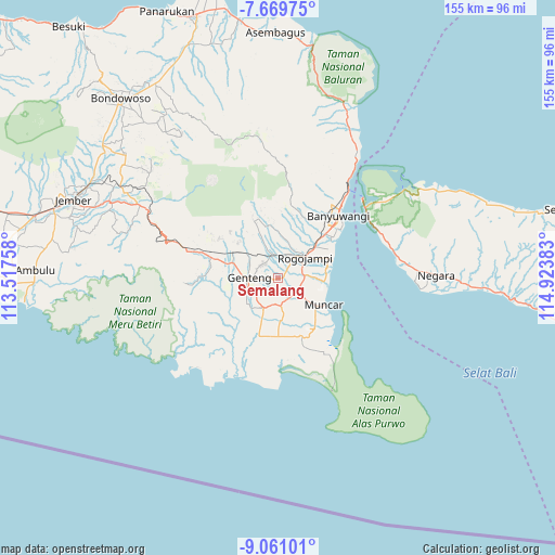
Semalang GPS coordinates[2]
8° 21' 57.6" South, 114° 13' 14.52" East
| Map corner | latitude | longitude |
|---|---|---|
| Upper-left | -7.66975°, | 113.51758° |
| Center: | -8.366°, | 114.2207° |
| Lower-right: | -9.06101°, | 114.92383° |
| Map W x H: | 154.7×154.7 km | = 96.1×96.1mi |
| max Lat: | 5.88969° ⇑79.3% North |
| Semalang: | -8.366° |
| min Lat: | ⇓20.7% South -10.934° |
| min Long | Semalang | max Long |
| 95.1345° | 114.2207° | 140.9419° |
| W 68.5%⇐ | ⇒31.5% E |
Elevation
Elevation of Semalang is 127 m = 417 ft, and this is 102.7 m = 337 ft below average elevation for this country.
| Max E: |
3185 m = 10449 ft | 44.6% |
| Avg. | 229.7 m = 754 ft | |
| Semalang | 127 m = 417 ft | |
Min E: |
-1 m = -3 ft | 55.4% |
See also: Indonesia elevation on elevation.city.
Geographical zone
Semalang is located in South Torrid zone (between Equator and Tropic of Capricorn). Distance of Equator is 930.2 km =578 mi to North.| Distance of | km | miles | from Semalang |
|---|---|---|---|
| Equator | 930.2 | 578 | to North |
| Tropic Capricorn | 1675.7 | 1041.2 | to South |
| Antarctic Circle | 6471 | 4020.9 | to South |
| South Pole | 9076.8 | 5640.1 | to South |


Nearby cities:
15 places around Semalang: (largest is in red/bold)
• Cantuk Kidul
7.6 km =4.7 mi,  5°
5°
• Dadapan
5.7 km =3.5 mi,  329°
329°
• Genteng
7.8 km =4.8 mi,  269°
269°
• Karanglo
6.6 km =4.1 mi,  108°
108°
• Krajan
4.1 km =2.5 mi,  39°
39°
• Krajan
5.8 km =3.6 mi, 10°
• Krajan
6.4 km =4 mi, 270°
• Krajan
6.4 km =4 mi,  338°
338°
• Krajan
7 km =4.3 mi,  350°
350°
• Melikkrajan
2.1 km =1.3 mi,  22°
22°
• Pasinan Barat
6 km =3.7 mi, 17°
• Payaman
3.4 km =2.1 mi,  70°
70°
• Singojuruh
5.7 km =3.5 mi, 14°
• Srono
6.3 km =3.9 mi,  126°
126°
• Sumberan
6.5 km =4 mi, 126°
Sources, notices
• [Note1] Compared only with cities in Indonesia existing in our database
• [Src1] Map data: © OpenStreetMap contributors (CC-BY-SA)
• [Src2] Other city data from geonames.org with taken over terms of usage.
• [Src3] Geographical zone / Annual Mean Temperature by Robert A. Rohde @ Wikipedia
