Srono geodata
Srono (East Java) is a populated place; located in Indonesia in Asia/Jakarta (GMT+7) time zone. With population of 36,260 people, there are 283 cities with bigger population in this country. Compared to other cities in Indonesia, 80.4% of cities are located further ↑North; 68.7% of cities are located further ←West and 59.8% of cities have higher elevation than Srono. Note1


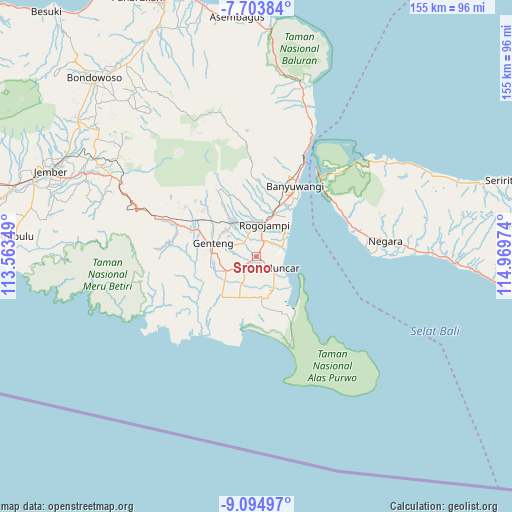
Srono GPS coordinates[2]
8° 24' 0.108" South, 114° 15' 59.796" East
| Map corner | latitude | longitude |
|---|---|---|
| Upper-left | -7.70384°, | 113.56349° |
| Center: | -8.40003°, | 114.26661° |
| Lower-right: | -9.09497°, | 114.96974° |
| Map W x H: | 154.7×154.7 km | = 96.1×96.1mi |
| max Lat: | 5.88969° ⇑80.4% North |
| Srono: | -8.40003° |
| min Lat: | ⇓19.6% South -10.934° |
| min Long | Srono | max Long |
| 95.1345° | 114.26661° | 140.9419° |
| W 68.7%⇐ | ⇒31.3% E |
Elevation
Elevation of Srono is 60 m = 197 ft, and this is 169.7 m = 557 ft below average elevation for this country.
| Max E: |
3185 m = 10449 ft | 59.8% |
| Avg. | 229.7 m = 754 ft | |
| Srono | 60 m = 197 ft | |
Min E: |
-1 m = -3 ft | 40.2% |
See also: Indonesia elevation on elevation.city.
Geographical zone
Srono is located in South Torrid zone (between Equator and Tropic of Capricorn). Distance of Equator is 934 km =580.4 mi to North.| Distance of | km | miles | from Srono |
|---|---|---|---|
| Equator | 934 | 580.4 | to North |
| Tropic Capricorn | 1671.9 | 1038.9 | to South |
| Antarctic Circle | 6467.2 | 4018.5 | to South |
| South Pole | 9073.1 | 5637.8 | to South |


Nearby cities:
15 places around Srono: (largest is in red/bold)
• Bagorejo
4.2 km =2.6 mi,  83°
83°
• Curahpacul Satu
6.9 km =4.3 mi,  157°
157°
• Karanglo
2.1 km =1.3 mi,  35°
35°
• Kedungrejo
7.4 km =4.6 mi,  126°
126°
• Kedungwringin Satu
9.6 km =6 mi, 128°
• Krajan
7.3 km =4.5 mi,  340°
340°
• Kumendung Satu
7.5 km =4.7 mi, 75°
• Melikkrajan
7.2 km =4.5 mi,  323°
323°
• Muncar
8.2 km =5.1 mi,  116°
116°
• Payaman
5.2 km =3.2 mi, 339°
• Rejoagung Satu
5.4 km =3.4 mi,  63°
63°
• Rumping
8 km =5 mi,  173°
173°
• Semalang
6.3 km =3.9 mi,  306°
306°
• Sumberan
0.2 km =0.1 mi,  100°
100°
• Sumbersewu
6.6 km =4.1 mi,  91°
91°
Sources, notices
• [Note1] Compared only with cities in Indonesia existing in our database
• [Src1] Map data: © OpenStreetMap contributors (CC-BY-SA)
• [Src2] Other city data from geonames.org with taken over terms of usage.
• [Src3] Geographical zone / Annual Mean Temperature by Robert A. Rohde @ Wikipedia
