Genteng geodata
Genteng (East Java) is a populated place; located in Indonesia in Asia/Jakarta (GMT+7) time zone. With population of 79,652 people, there are 162 cities with bigger population in this country. Compared to other cities in Indonesia, 79.3% of cities are located further ↑North; 68.2% of cities are located further ←West and 60.7% of cities have lower elevation than Genteng. Note1


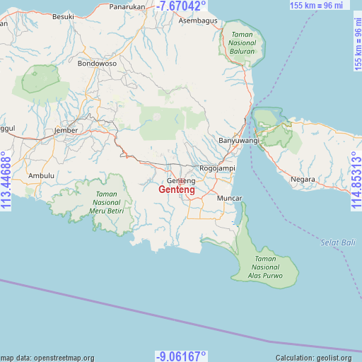
Genteng GPS coordinates[2]
8° 22' 0.012" South, 114° 9' 0" East
| Map corner | latitude | longitude |
|---|---|---|
| Upper-left | -7.67042°, | 113.44688° |
| Center: | -8.36667°, | 114.15° |
| Lower-right: | -9.06167°, | 114.85313° |
| Map W x H: | 154.7×154.7 km | = 96.1×96.1mi |
| max Lat: | 5.88969° ⇑79.3% North |
| Genteng: | -8.36667° |
| min Lat: | ⇓20.7% South -10.934° |
| min Long | Genteng | max Long |
| 95.1345° | 114.15° | 140.9419° |
| W 68.2%⇐ | ⇒31.8% E |
Elevation
Elevation of Genteng is 172 m = 564 ft, and this is 57.7 m = 189 ft below average elevation for this country.
| Max E: |
3185 m = 10449 ft | 39.3% |
| Avg. | 229.7 m = 754 ft | |
| Genteng | 172 m = 564 ft | |
Min E: |
-1 m = -3 ft | 60.7% |
See also: Genteng elevation on elevation.city.
Geographical zone
Genteng is located in South Torrid zone (between Equator and Tropic of Capricorn). Distance of Equator is 930.3 km =578.1 mi to North.| Distance of | km | miles | from Genteng |
|---|---|---|---|
| Equator | 930.3 | 578.1 | to North |
| Tropic Capricorn | 1675.6 | 1041.2 | to South |
| Antarctic Circle | 6470.9 | 4020.8 | to South |
| South Pole | 9076.8 | 5640.1 | to South |


Nearby cities:
15 places around Genteng: (largest is in red/bold)
• Balokan
4.1 km =2.5 mi,  233°
233°
• Blokagung
9.6 km =6 mi,  211°
211°
• Dadapan
7 km =4.3 mi,  44°
44°
• Gambiran Satu
3.1 km =1.9 mi,  187°
187°
• Kopen
0.5 km =0.3 mi,  344°
344°
• Kopen
7 km =4.3 mi,  22°
22°
• Krajan
1.4 km =0.9 mi,  83°
83°
• Krajan
1.7 km =1.1 mi,  277°
277°
• Krajan
4.6 km =2.9 mi,  250°
250°
• Krajan
8.1 km =5 mi, 42°
• Krajan
9.6 km =6 mi, 43°
• Melikkrajan
8.8 km =5.5 mi, 76°
• Purwojoyo
6.9 km =4.3 mi,  303°
303°
• Semalang
7.8 km =4.8 mi,  89°
89°
• Sempu
5.4 km =3.4 mi,  2°
2°
Sources, notices
• [Note1] Compared only with cities in Indonesia existing in our database
• [Src1] Map data: © OpenStreetMap contributors (CC-BY-SA)
• [Src2] Other city data from geonames.org with taken over terms of usage.
• [Src3] Geographical zone / Annual Mean Temperature by Robert A. Rohde @ Wikipedia
