Payangan Tengah geodata
Payangan Tengah (Bali) is a seat of a fourth-order administrative division; located in Indonesia in Asia/Makassar (GMT+8) time zone. In our database, there are 407 cities with bigger population. Compared to other cities in Indonesia, 81.3% of cities are located further ↑North; 72.2% of cities are located further ←West and 77.1% of cities have lower elevation than Payangan Tengah. Note1


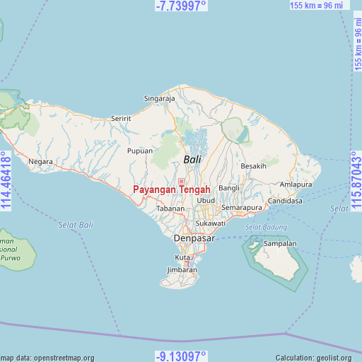
Payangan Tengah GPS coordinates[2]
8° 26' 9.96" South, 115° 10' 2.28" East
| Map corner | latitude | longitude |
|---|---|---|
| Upper-left | -7.73997°, | 114.46418° |
| Center: | -8.4361°, | 115.1673° |
| Lower-right: | -9.13097°, | 115.87043° |
| Map W x H: | 154.7×154.7 km | = 96.1×96.1mi |
| max Lat: | 5.88969° ⇑81.3% North |
| Payangan Tengah: | -8.4361° |
| min Lat: | ⇓18.7% South -10.934° |
| min Long | Payangan Tengah | max Long |
| 95.1345° | 115.1673° | 140.9419° |
| W 72.2%⇐ | ⇒27.8% E |
Elevation
Elevation of Payangan Tengah is 385 m = 1263 ft, and this is 155.3 m = 510 ft above average elevation for this country.
| Max E: |
3185 m = 10449 ft | 22.9% |
| Payangan Tengah | 385 m 1263 ft | |
| Avg. | 229.7 m = 754 ft | |
Min E: |
-1 m = -3 ft | 77.1% |
See also: Indonesia elevation on elevation.city.
Geographical zone
Payangan Tengah is located in South Torrid zone (between Equator and Tropic of Capricorn). Distance of Equator is 938 km =582.8 mi to North.| Distance of | km | miles | from Payangan Tengah |
|---|---|---|---|
| Equator | 938 | 582.8 | to North |
| Tropic Capricorn | 1667.9 | 1036.4 | to South |
| Antarctic Circle | 6463.2 | 4016 | to South |
| South Pole | 9069.1 | 5635.3 | to South |


Nearby cities:
15 places around Payangan Tengah: (largest is in red/bold)
• Baleagung
4.3 km =2.7 mi,  244°
244°
• Basa
4.2 km =2.6 mi,  178°
178°
• Beaung Tengah
1.8 km =1.1 mi,  336°
336°
• Buruan Tengah
4 km =2.5 mi,  232°
232°
• Dajanpeken
4.1 km =2.5 mi,  154°
154°
• Penatahan Kaja
4.6 km =2.9 mi,  270°
270°
• Penebel
3 km =1.9 mi,  305°
305°
• Pergan
3.2 km =2 mi,  70°
70°
• Petiga
1.1 km =0.7 mi,  88°
88°
• Pohgending Kangin
2.4 km =1.5 mi,  281°
281°
• Pohgending Kawan
2.7 km =1.7 mi, 270°
• Tembau
3.7 km =2.3 mi, 178°
• Tua
3.1 km =1.9 mi,  28°
28°
• Tuka
3.4 km =2.1 mi,  82°
82°
• Tunjuk Selatan
4.7 km =2.9 mi,  201°
201°
Sources, notices
• [Note1] Compared only with cities in Indonesia existing in our database
• [Src1] Map data: © OpenStreetMap contributors (CC-BY-SA)
• [Src2] Other city data from geonames.org with taken over terms of usage.
• [Src3] Geographical zone / Annual Mean Temperature by Robert A. Rohde @ Wikipedia
