Pergan geodata
Pergan (Bali) is a seat of a fourth-order administrative division; located in Indonesia in Asia/Makassar (GMT+8) time zone. In our database, there are 407 cities with bigger population. Compared to other cities in Indonesia, 81% of cities are located further ↑North; 72.5% of cities are located further ←West and 79.3% of cities have lower elevation than Pergan. Note1


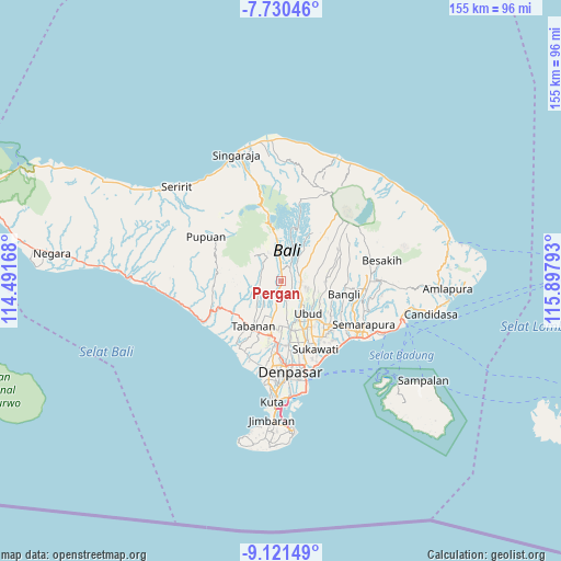
Pergan GPS coordinates[2]
8° 25' 35.76" South, 115° 11' 41.28" East
| Map corner | latitude | longitude |
|---|---|---|
| Upper-left | -7.73046°, | 114.49168° |
| Center: | -8.4266°, | 115.1948° |
| Lower-right: | -9.12149°, | 115.89793° |
| Map W x H: | 154.7×154.7 km | = 96.1×96.1mi |
| max Lat: | 5.88969° ⇑81% North |
| Pergan: | -8.4266° |
| min Lat: | ⇓19% South -10.934° |
| min Long | Pergan | max Long |
| 95.1345° | 115.1948° | 140.9419° |
| W 72.5%⇐ | ⇒27.5% E |
Elevation
Elevation of Pergan is 419 m = 1375 ft, and this is 189.3 m = 621 ft above average elevation for this country.
| Max E: |
3185 m = 10449 ft | 20.7% |
| Pergan | 419 m 1375 ft | |
| Avg. | 229.7 m = 754 ft | |
Min E: |
-1 m = -3 ft | 79.3% |
See also: Indonesia elevation on elevation.city.
Geographical zone
Pergan is located in South Torrid zone (between Equator and Tropic of Capricorn). Distance of Equator is 937 km =582.2 mi to North.| Distance of | km | miles | from Pergan |
|---|---|---|---|
| Equator | 937 | 582.2 | to North |
| Tropic Capricorn | 1669 | 1037.1 | to South |
| Antarctic Circle | 6464.2 | 4016.7 | to South |
| South Pole | 9070.1 | 5635.9 | to South |


Nearby cities:
15 places around Pergan: (largest is in red/bold)
• Bayad
5.6 km =3.5 mi,  114°
114°
• Beaung Tengah
3.8 km =2.4 mi,  278°
278°
• Dajanpeken
4.9 km =3 mi,  194°
194°
• Luwus
3.1 km =1.9 mi,  1°
1°
• Melinggih
5.5 km =3.4 mi,  95°
95°
• Pangsan
3.2 km =2 mi,  65°
65°
• Payangan Tengah
3.2 km =2 mi,  250°
250°
• Pemijian
3.7 km =2.3 mi,  133°
133°
• Penebel
5.5 km =3.4 mi, 277°
• Peneng
5.2 km =3.2 mi,  359°
359°
• Petang
4.3 km =2.7 mi,  37°
37°
• Petiga
2.2 km =1.4 mi,  242°
242°
• Pohgending Kangin
5.5 km =3.4 mi,  264°
264°
• Tua
2.3 km =1.4 mi,  317°
317°
• Tuka
0.7 km =0.4 mi,  149°
149°
Sources, notices
• [Note1] Compared only with cities in Indonesia existing in our database
• [Src1] Map data: © OpenStreetMap contributors (CC-BY-SA)
• [Src2] Other city data from geonames.org with taken over terms of usage.
• [Src3] Geographical zone / Annual Mean Temperature by Robert A. Rohde @ Wikipedia
