Banjar Tengah geodata
Banjar Tengah (Bali) is a seat of a fourth-order administrative division; located in Indonesia in Asia/Makassar (GMT+8) time zone. In our database, there are 407 cities with bigger population. Compared to other cities in Indonesia, 83.4% of cities are located further ↑North; 72.5% of cities are located further ←West and 65% of cities have lower elevation than Banjar Tengah. Note1


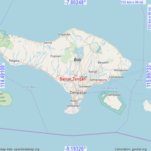
Banjar Tengah GPS coordinates[2]
8° 29' 54.6" South, 115° 11' 39.12" East
| Map corner | latitude | longitude |
|---|---|---|
| Upper-left | -7.80248°, | 114.49108° |
| Center: | -8.4985°, | 115.1942° |
| Lower-right: | -9.19326°, | 115.89733° |
| Map W x H: | 154.6×154.6 km | = 96.1×96.1mi |
| max Lat: | 5.88969° ⇑83.4% North |
| Banjar Tengah: | -8.4985° |
| min Lat: | ⇓16.6% South -10.934° |
| min Long | Banjar Tengah | max Long |
| 95.1345° | 115.1942° | 140.9419° |
| W 72.5%⇐ | ⇒27.5% E |
Elevation
Elevation of Banjar Tengah is 222 m = 728 ft, and this is 7.7 m = 25 ft below average elevation for this country.
| Max E: |
3185 m = 10449 ft | 35% |
| Avg. | 229.7 m = 754 ft | |
| Banjar Tengah | 222 m = 728 ft | |
Min E: |
-1 m = -3 ft | 65% |
See also: Indonesia elevation on elevation.city.
Geographical zone
Banjar Tengah is located in South Torrid zone (between Equator and Tropic of Capricorn). Distance of Equator is 944.9 km =587.1 mi to North.| Distance of | km | miles | from Banjar Tengah |
|---|---|---|---|
| Equator | 944.9 | 587.1 | to North |
| Tropic Capricorn | 1661 | 1032.1 | to South |
| Antarctic Circle | 6456.2 | 4011.7 | to South |
| South Pole | 9062.1 | 5630.9 | to South |


Nearby cities:
15 places around Banjar Tengah: (largest is in red/bold)
• Banjar Badung Tengah
1.1 km =0.7 mi,  147°
147°
• Banjar Batanyuh Kaja
3.1 km =1.9 mi,  250°
250°
• Banjar Kedua
2.4 km =1.5 mi,  200°
200°
• Banjar Kembangsari
2.2 km =1.4 mi,  123°
123°
• Banjar Keraman
3.8 km =2.4 mi, 149°
• Banjar Sayanbaleran
1.7 km =1.1 mi,  241°
241°
• Banjar Sempidi
3 km =1.9 mi,  155°
155°
• Banjar Tengahbelayu
3.4 km =2.1 mi, 239°
• Banjar Ulapan Satu
2.5 km =1.6 mi, 119°
• Basa
3.9 km =2.4 mi,  313°
313°
• Brahmana
2.2 km =1.4 mi,  53°
53°
• Dajanpeken
3.4 km =2.1 mi,  340°
340°
• Kekeran
2 km =1.2 mi,  295°
295°
• Kuwumkumambal
3 km =1.9 mi,  293°
293°
• Pegongan
3.8 km =2.4 mi,  67°
67°
Sources, notices
• [Note1] Compared only with cities in Indonesia existing in our database
• [Src1] Map data: © OpenStreetMap contributors (CC-BY-SA)
• [Src2] Other city data from geonames.org with taken over terms of usage.
• [Src3] Geographical zone / Annual Mean Temperature by Robert A. Rohde @ Wikipedia
