Sukorejo geodata
Sukorejo (East Java) is a seat of a fourth-order administrative division; located in Indonesia in Asia/Jakarta (GMT+7) time zone. In our database, there are 407 cities with bigger population. Compared to other cities in Indonesia, 69.9% of cities are located further ↑North; 51.7% of cities are located further ←West and 58.5% of cities have lower elevation than Sukorejo. Note1


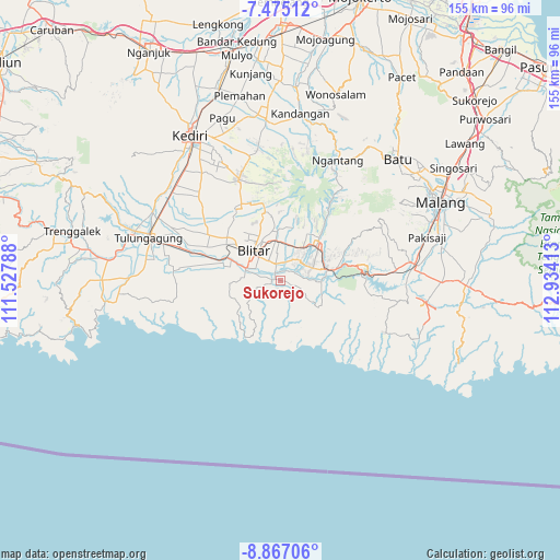
Sukorejo GPS coordinates[2]
8° 10' 18.12" South, 112° 13' 51.6" East
| Map corner | latitude | longitude |
|---|---|---|
| Upper-left | -7.47512°, | 111.52788° |
| Center: | -8.1717°, | 112.231° |
| Lower-right: | -8.86706°, | 112.93413° |
| Map W x H: | 154.8×154.8 km | = 96.2×96.2mi |
| max Lat: | 5.88969° ⇑69.9% North |
| Sukorejo: | -8.1717° |
| min Lat: | ⇓30.1% South -10.934° |
| min Long | Sukorejo | max Long |
| 95.1345° | 112.231° | 140.9419° |
| W 51.7%⇐ | ⇒48.3% E |
Elevation
Elevation of Sukorejo is 150 m = 492 ft, and this is 79.7 m = 261 ft below average elevation for this country.
| Max E: |
3185 m = 10449 ft | 41.5% |
| Avg. | 229.7 m = 754 ft | |
| Sukorejo | 150 m = 492 ft | |
Min E: |
-1 m = -3 ft | 58.5% |
See also: Indonesia elevation on elevation.city.
Geographical zone
Sukorejo is located in South Torrid zone (between Equator and Tropic of Capricorn). Distance of Equator is 908.6 km =564.6 mi to North.| Distance of | km | miles | from Sukorejo |
|---|---|---|---|
| Equator | 908.6 | 564.6 | to North |
| Tropic Capricorn | 1697.3 | 1054.7 | to South |
| Antarctic Circle | 6492.6 | 4034.3 | to South |
| South Pole | 9098.5 | 5653.5 | to South |


Nearby cities:
15 places around Sukorejo: (largest is in red/bold)
• Bacem
2.5 km =1.6 mi,  177°
177°
• Jegu
2.3 km =1.4 mi,  10°
10°
• Jinglong
0.7 km =0.4 mi,  357°
357°
• Kanigoro
4.8 km =3 mi,  344°
344°
• Karangsono
4.4 km =2.7 mi,  322°
322°
• Kedungbunder
2.6 km =1.6 mi,  255°
255°
• Kembangarum
2.1 km =1.3 mi,  311°
311°
• Klampok
4.1 km =2.5 mi,  254°
254°
• Lodoyo
1.9 km =1.2 mi, 307°
• Rampalombo
4.8 km =3 mi,  128°
128°
• Satrejan
3.4 km =2.1 mi, 340°
• Serut
5.2 km =3.2 mi, 307°
• Sumberrejo
1.2 km =0.7 mi,  141°
141°
• Sutojayan
1.8 km =1.1 mi, 245°
• Wonorejo
1.4 km =0.9 mi,  276°
276°
Sources, notices
• [Note1] Compared only with cities in Indonesia existing in our database
• [Src1] Map data: © OpenStreetMap contributors (CC-BY-SA)
• [Src2] Other city data from geonames.org with taken over terms of usage.
• [Src3] Geographical zone / Annual Mean Temperature by Robert A. Rohde @ Wikipedia
