Kedungbunder geodata
Kedungbunder (East Java) is a seat of a fourth-order administrative division; located in Indonesia in Asia/Jakarta (GMT+7) time zone. In our database, there are 407 cities with bigger population. Compared to other cities in Indonesia, 70.2% of cities are located further ↑North; 51.5% of cities are located further ←West and 58.2% of cities have lower elevation than Kedungbunder. Note1


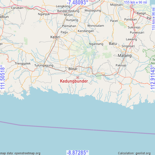
Kedungbunder GPS coordinates[2]
8° 10' 39" South, 112° 12' 29.88" East
| Map corner | latitude | longitude |
|---|---|---|
| Upper-left | -7.48093°, | 111.50518° |
| Center: | -8.1775°, | 112.2083° |
| Lower-right: | -8.87285°, | 112.91143° |
| Map W x H: | 154.8×154.8 km | = 96.2×96.2mi |
| max Lat: | 5.88969° ⇑70.2% North |
| Kedungbunder: | -8.1775° |
| min Lat: | ⇓29.8% South -10.934° |
| min Long | Kedungbunder | max Long |
| 95.1345° | 112.2083° | 140.9419° |
| W 51.5%⇐ | ⇒48.5% E |
Elevation
Elevation of Kedungbunder is 147 m = 482 ft, and this is 82.7 m = 271 ft below average elevation for this country.
| Max E: |
3185 m = 10449 ft | 41.8% |
| Avg. | 229.7 m = 754 ft | |
| Kedungbunder | 147 m = 482 ft | |
Min E: |
-1 m = -3 ft | 58.2% |
See also: Indonesia elevation on elevation.city.
Geographical zone
Kedungbunder is located in South Torrid zone (between Equator and Tropic of Capricorn). Distance of Equator is 909.3 km =565 mi to North.| Distance of | km | miles | from Kedungbunder |
|---|---|---|---|
| Equator | 909.3 | 565 | to North |
| Tropic Capricorn | 1696.7 | 1054.3 | to South |
| Antarctic Circle | 6491.9 | 4033.9 | to South |
| South Pole | 9097.8 | 5653.1 | to South |


Nearby cities:
15 places around Kedungbunder: (largest is in red/bold)
• Bacem
3.2 km =2 mi,  126°
126°
• Darungan Satu
4 km =2.5 mi,  299°
299°
• Jegu
4.1 km =2.5 mi,  45°
45°
• Jinglong
2.8 km =1.7 mi,  62°
62°
• Karangsono
4.2 km =2.6 mi,  356°
356°
• Kembangarum
2.2 km =1.4 mi,  24°
24°
• Klampok
1.6 km =1 mi,  251°
251°
• Lodoyo
2.1 km =1.3 mi,  28°
28°
• Plosorejo
4.7 km =2.9 mi, 298°
• Satrejan
4.1 km =2.5 mi, 19°
• Serut
4.1 km =2.5 mi,  336°
336°
• Sukorejo
2.6 km =1.6 mi,  75°
75°
• Sumberrejo
3.3 km =2.1 mi,  95°
95°
• Sutojayan
0.9 km =0.6 mi, 97°
• Wonorejo
1.4 km =0.9 mi, 53°
Sources, notices
• [Note1] Compared only with cities in Indonesia existing in our database
• [Src1] Map data: © OpenStreetMap contributors (CC-BY-SA)
• [Src2] Other city data from geonames.org with taken over terms of usage.
• [Src3] Geographical zone / Annual Mean Temperature by Robert A. Rohde @ Wikipedia
