Bodak geodata
Bodak (West Nusa Tenggara) is a seat of a fourth-order administrative division; located in Indonesia in Asia/Makassar (GMT+8) time zone. In our database, there are 407 cities with bigger population. Compared to other cities in Indonesia, 88.2% of cities are located further ↑North; 76.7% of cities are located further ←West and 70.7% of cities have lower elevation than Bodak. Note1


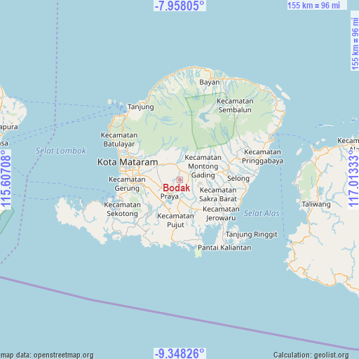
Bodak GPS coordinates[2]
8° 39' 13.68" South, 116° 18' 36.72" East
| Map corner | latitude | longitude |
|---|---|---|
| Upper-left | -7.95805°, | 115.60708° |
| Center: | -8.6538°, | 116.3102° |
| Lower-right: | -9.34826°, | 117.01333° |
| Map W x H: | 154.6×154.6 km | = 96.1×96.1mi |
| max Lat: | 5.88969° ⇑88.2% North |
| Bodak: | -8.6538° |
| min Lat: | ⇓11.8% South -10.934° |
| min Long | Bodak | max Long |
| 95.1345° | 116.3102° | 140.9419° |
| W 76.7%⇐ | ⇒23.3% E |
Elevation
Elevation of Bodak is 301 m = 988 ft, and this is 71.3 m = 234 ft above average elevation for this country.
| Max E: |
3185 m = 10449 ft | 29.3% |
| Bodak | 301 m 988 ft | |
| Avg. | 229.7 m = 754 ft | |
Min E: |
-1 m = -3 ft | 70.7% |
See also: Indonesia elevation on elevation.city.
Geographical zone
Bodak is located in South Torrid zone (between Equator and Tropic of Capricorn). Distance of Equator is 962.2 km =597.9 mi to North.| Distance of | km | miles | from Bodak |
|---|---|---|---|
| Equator | 962.2 | 597.9 | to North |
| Tropic Capricorn | 1643.7 | 1021.3 | to South |
| Antarctic Circle | 6439 | 4001 | to South |
| South Pole | 9044.8 | 5620.2 | to South |


Nearby cities:
15 places around Bodak: (largest is in red/bold)
• Barabali
3.1 km =1.9 mi,  357°
357°
• Barejulat
6.4 km =4 mi,  264°
264°
• Beraim
6.7 km =4.2 mi,  151°
151°
• Darmaji
3.5 km =2.2 mi,  124°
124°
• Kembangkerang Satu
6.4 km =4 mi,  348°
348°
• Kopang Satu
5.1 km =3.2 mi,  63°
63°
• Lendangtampel Daya
5.2 km =3.2 mi,  331°
331°
• Lilin Satu
7.1 km =4.4 mi, 57°
• Mantang
4.3 km =2.7 mi,  5°
5°
• Montongbelok
3.3 km =2.1 mi,  39°
39°
• Montonggamang
7.1 km =4.4 mi,  72°
72°
• Pagutan
4.1 km =2.5 mi,  315°
315°
• Pediti
7.6 km =4.7 mi,  16°
16°
• Praya
7.2 km =4.5 mi,  217°
217°
• Selebung Satu
5.9 km =3.7 mi, 13°
Sources, notices
• [Note1] Compared only with cities in Indonesia existing in our database
• [Src1] Map data: © OpenStreetMap contributors (CC-BY-SA)
• [Src2] Other city data from geonames.org with taken over terms of usage.
• [Src3] Geographical zone / Annual Mean Temperature by Robert A. Rohde @ Wikipedia
