Praya geodata
Praya (West Nusa Tenggara) is a seat of a third-order administrative division; located in Indonesia in Asia/Makassar (GMT+8) time zone. With population of 35,183 people, there are 289 cities with bigger population in this country. Compared to other cities in Indonesia, 89.4% of cities are located further ↑North; 76.6% of cities are located further ←West and 51.6% of cities have lower elevation than Praya. Note1


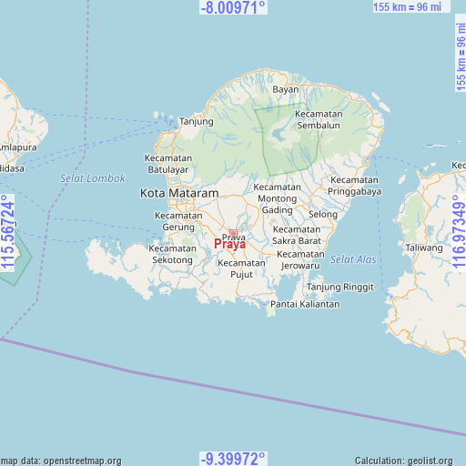
Praya GPS coordinates[2]
8° 42' 19.296" South, 116° 16' 13.296" East
| Map corner | latitude | longitude |
|---|---|---|
| Upper-left | -8.00971°, | 115.56724° |
| Center: | -8.70536°, | 116.27036° |
| Lower-right: | -9.39972°, | 116.97349° |
| Map W x H: | 154.6×154.6 km | = 96.1×96.1mi |
| max Lat: | 5.88969° ⇑89.4% North |
| Praya: | -8.70536° |
| min Lat: | ⇓10.6% South -10.934° |
| min Long | Praya | max Long |
| 95.1345° | 116.27036° | 140.9419° |
| W 76.6%⇐ | ⇒23.4% E |
Elevation
Elevation of Praya is 108 m = 354 ft, and this is 121.7 m = 399 ft below average elevation for this country.
| Max E: |
3185 m = 10449 ft | 48.4% |
| Avg. | 229.7 m = 754 ft | |
| Praya | 108 m = 354 ft | |
Min E: |
-1 m = -3 ft | 51.6% |
See also: Indonesia elevation on elevation.city.
Geographical zone
Praya is located in South Torrid zone (between Equator and Tropic of Capricorn). Distance of Equator is 967.9 km =601.4 mi to North.| Distance of | km | miles | from Praya |
|---|---|---|---|
| Equator | 967.9 | 601.4 | to North |
| Tropic Capricorn | 1638 | 1017.8 | to South |
| Antarctic Circle | 6433.2 | 3997.4 | to South |
| South Pole | 9039.1 | 5616.6 | to South |


Nearby cities:
15 places around Praya: (largest is in red/bold)
• Ampanlolat
8.1 km =5 mi,  258°
258°
• Bagiktinggang
6 km =3.7 mi,  142°
142°
• Barejulat
5.5 km =3.4 mi,  338°
338°
• Batutulis
6.4 km =4 mi,  284°
284°
• Beraim
7.6 km =4.7 mi,  91°
91°
• Blong Daye
5.1 km =3.2 mi,  285°
285°
• Bodak
7.2 km =4.5 mi,  37°
37°
• Karang Daye
5.4 km =3.4 mi,  216°
216°
• Karangdalam
4.7 km =2.9 mi, 219°
• Majan
5.3 km =3.3 mi,  120°
120°
• Pendaleman
4 km =2.5 mi,  305°
305°
• Penunjak
5.5 km =3.4 mi, 216°
• Permas
7.8 km =4.8 mi,  242°
242°
• Semayan
2.1 km =1.3 mi, 135°
• Tanakawu Dua
7.6 km =4.7 mi,  182°
182°
Sources, notices
• [Note1] Compared only with cities in Indonesia existing in our database
• [Src1] Map data: © OpenStreetMap contributors (CC-BY-SA)
• [Src2] Other city data from geonames.org with taken over terms of usage.
• [Src3] Geographical zone / Annual Mean Temperature by Robert A. Rohde @ Wikipedia
