Bhokadoke geodata
Bhokadoke (East Nusa Tenggara) is a seat of a fourth-order administrative division; located in Indonesia in Asia/Makassar (GMT+8) time zone. In our database, there are 407 cities with bigger population. Compared to other cities in Indonesia, 91.4% of cities are located further ↑North; 86.4% of cities are located further ←West and 84.9% of cities have lower elevation than Bhokadoke. Note1


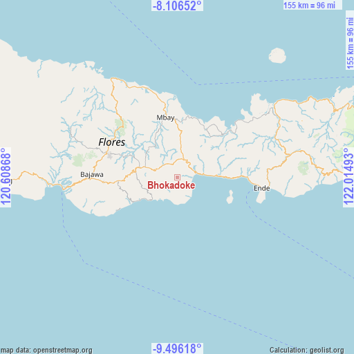
Bhokadoke GPS coordinates[2]
8° 48' 7.2" South, 121° 18' 42.48" East
| Map corner | latitude | longitude |
|---|---|---|
| Upper-left | -8.10652°, | 120.60868° |
| Center: | -8.802°, | 121.3118° |
| Lower-right: | -9.49618°, | 122.01493° |
| Map W x H: | 154.5×154.5 km | = 96×96mi |
| max Lat: | 5.88969° ⇑91.4% North |
| Bhokadoke: | -8.802° |
| min Lat: | ⇓8.6% South -10.934° |
| min Long | Bhokadoke | max Long |
| 95.1345° | 121.3118° | 140.9419° |
| W 86.4%⇐ | ⇒13.6% E |
Elevation
Elevation of Bhokadoke is 517 m = 1696 ft, and this is 287.3 m = 943 ft above average elevation for this country.
| Max E: |
3185 m = 10449 ft | 15.1% |
| Bhokadoke | 517 m 1696 ft | |
| Avg. | 229.7 m = 754 ft | |
Min E: |
-1 m = -3 ft | 84.9% |
See also: Indonesia elevation on elevation.city.
Geographical zone
Bhokadoke is located in South Torrid zone (between Equator and Tropic of Capricorn). Distance of Equator is 978.7 km =608.1 mi to North.| Distance of | km | miles | from Bhokadoke |
|---|---|---|---|
| Equator | 978.7 | 608.1 | to North |
| Tropic Capricorn | 1627.2 | 1011.1 | to South |
| Antarctic Circle | 6422.5 | 3990.8 | to South |
| South Pole | 9028.4 | 5610 | to South |


Nearby cities:
15 places around Bhokadoke: (largest is in red/bold)
• Aegela
8.2 km =5.1 mi,  19°
19°
• Jawagae
9.1 km =5.7 mi,  294°
294°
• Lena
4.7 km =2.9 mi,  345°
345°
• Lokatadho
4.3 km =2.7 mi,  251°
251°
• Maunuri
10.4 km =6.5 mi,  199°
199°
• Mbeku
7.7 km =4.8 mi, 201°
• Mulakoli
10.3 km =6.4 mi,  268°
268°
• Nangaroro
9 km =5.6 mi,  79°
79°
• Nasawewe
9.7 km =6 mi, 201°
• Pamakoe
8.3 km =5.2 mi,  305°
305°
• Pau
6.1 km =3.8 mi,  193°
193°
• Pusu
7.8 km =4.8 mi,  244°
244°
• Tibakisa
7 km =4.3 mi, 354°
• Wologama
7.9 km =4.9 mi, 289°
• Wolowada
7.2 km =4.5 mi,  213°
213°
Sources, notices
• [Note1] Compared only with cities in Indonesia existing in our database
• [Src1] Map data: © OpenStreetMap contributors (CC-BY-SA)
• [Src2] Other city data from geonames.org with taken over terms of usage.
• [Src3] Geographical zone / Annual Mean Temperature by Robert A. Rohde @ Wikipedia
