Aegela geodata
Aegela (East Nusa Tenggara) is a seat of a fourth-order administrative division; located in Indonesia in Asia/Makassar (GMT+8) time zone. In our database, there are 407 cities with bigger population. Compared to other cities in Indonesia, 90% of cities are located further ↑North; 86.5% of cities are located further ←West and 87.9% of cities have lower elevation than Aegela. Note1


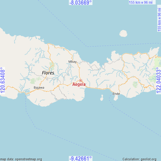
Aegela GPS coordinates[2]
8° 43' 56.28" South, 121° 20' 13.92" East
| Map corner | latitude | longitude |
|---|---|---|
| Upper-left | -8.03669°, | 120.63408° |
| Center: | -8.7323°, | 121.3372° |
| Lower-right: | -9.42661°, | 122.04033° |
| Map W x H: | 154.5×154.5 km | = 96×96mi |
| max Lat: | 5.88969° ⇑90% North |
| Aegela: | -8.7323° |
| min Lat: | ⇓10% South -10.934° |
| min Long | Aegela | max Long |
| 95.1345° | 121.3372° | 140.9419° |
| W 86.5%⇐ | ⇒13.5% E |
Elevation
Elevation of Aegela is 583 m = 1913 ft, and this is 353.3 m = 1159 ft above average elevation for this country.
| Max E: |
3185 m = 10449 ft | 12.1% |
| Aegela | 583 m 1913 ft | |
| Avg. | 229.7 m = 754 ft | |
Min E: |
-1 m = -3 ft | 87.9% |
See also: Indonesia elevation on elevation.city.
Geographical zone
Aegela is located in South Torrid zone (between Equator and Tropic of Capricorn). Distance of Equator is 970.9 km =603.3 mi to North.| Distance of | km | miles | from Aegela |
|---|---|---|---|
| Equator | 970.9 | 603.3 | to North |
| Tropic Capricorn | 1635 | 1015.9 | to South |
| Antarctic Circle | 6430.2 | 3995.5 | to South |
| South Pole | 9036.1 | 5614.8 | to South |


Nearby cities:
15 places around Aegela: (largest is in red/bold)
• Bhokadoke
8.2 km =5.1 mi,  199°
199°
• Boanio
10.7 km =6.6 mi,  351°
351°
• Doma
5.4 km =3.4 mi, 348°
• Jawagae
11.8 km =7.3 mi,  250°
250°
• Jawatiwa
6.8 km =4.2 mi,  294°
294°
• Kuekobo
6.4 km =4 mi,  73°
73°
• Lena
5.1 km =3.2 mi,  230°
230°
• Lokatadho
11.4 km =7.1 mi,  217°
217°
• Nangaroro
8.6 km =5.3 mi,  135°
135°
• Oja
11.4 km =7.1 mi, 66°
• Pamakoe
10 km =6.2 mi, 252°
• Puukau
10.2 km =6.3 mi,  85°
85°
• Tibakisa
3.6 km =2.2 mi,  257°
257°
• Wologama
11.5 km =7.1 mi,  243°
243°
• Wolonio
14.2 km =8.8 mi, 246°
Sources, notices
• [Note1] Compared only with cities in Indonesia existing in our database
• [Src1] Map data: © OpenStreetMap contributors (CC-BY-SA)
• [Src2] Other city data from geonames.org with taken over terms of usage.
• [Src3] Geographical zone / Annual Mean Temperature by Robert A. Rohde @ Wikipedia
