Lokatadho geodata
Lokatadho (East Nusa Tenggara) is a seat of a fourth-order administrative division; located in Indonesia in Asia/Makassar (GMT+8) time zone. In our database, there are 407 cities with bigger population. Compared to other cities in Indonesia, 91.6% of cities are located further ↑North; 86.3% of cities are located further ←West and 90.9% of cities have lower elevation than Lokatadho. Note1


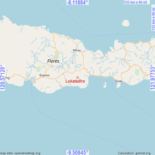
Lokatadho GPS coordinates[2]
8° 48' 51.48" South, 121° 16' 27.84" East
| Map corner | latitude | longitude |
|---|---|---|
| Upper-left | -8.11884°, | 120.57128° |
| Center: | -8.8143°, | 121.2744° |
| Lower-right: | -9.50845°, | 121.97753° |
| Map W x H: | 154.5×154.5 km | = 96×96mi |
| max Lat: | 5.88969° ⇑91.6% North |
| Lokatadho: | -8.8143° |
| min Lat: | ⇓8.4% South -10.934° |
| min Long | Lokatadho | max Long |
| 95.1345° | 121.2744° | 140.9419° |
| W 86.3%⇐ | ⇒13.7% E |
Elevation
Elevation of Lokatadho is 673 m = 2208 ft, and this is 443.3 m = 1454 ft above average elevation for this country.
| Max E: |
3185 m = 10449 ft | 9.1% |
| Lokatadho | 673 m 2208 ft | |
| Avg. | 229.7 m = 754 ft | |
Min E: |
-1 m = -3 ft | 90.9% |
See also: Indonesia elevation on elevation.city.
Geographical zone
Lokatadho is located in South Torrid zone (between Equator and Tropic of Capricorn). Distance of Equator is 980.1 km =609 mi to North.| Distance of | km | miles | from Lokatadho |
|---|---|---|---|
| Equator | 980.1 | 609 | to North |
| Tropic Capricorn | 1625.9 | 1010.3 | to South |
| Antarctic Circle | 6421.1 | 3989.9 | to South |
| South Pole | 9027 | 5609.1 | to South |


Nearby cities:
15 places around Lokatadho: (largest is in red/bold)
• Bhokadoke
4.3 km =2.7 mi,  71°
71°
• Gelu
7.4 km =4.6 mi,  237°
237°
• Jawagae
6.6 km =4.1 mi,  321°
321°
• Lena
6.6 km =4.1 mi,  26°
26°
• Lokawolo
7.6 km =4.7 mi,  247°
247°
• Maunuri
8.4 km =5.2 mi,  175°
175°
• Mbeku
6 km =3.7 mi,  167°
167°
• Mulakoli
6.3 km =3.9 mi,  280°
280°
• Nasawewe
7.6 km =4.7 mi, 175°
• Pamakoe
6.7 km =4.2 mi,  336°
336°
• Pau
5.3 km =3.3 mi,  149°
149°
• Pusu
3.6 km =2.2 mi,  234°
234°
• Wologama
5.2 km =3.2 mi, 319°
• Wolonio
7 km =4.3 mi,  299°
299°
• Wolowada
4.6 km =2.9 mi, 178°
Sources, notices
• [Note1] Compared only with cities in Indonesia existing in our database
• [Src1] Map data: © OpenStreetMap contributors (CC-BY-SA)
• [Src2] Other city data from geonames.org with taken over terms of usage.
• [Src3] Geographical zone / Annual Mean Temperature by Robert A. Rohde @ Wikipedia
