Gelu geodata
Gelu (East Nusa Tenggara) is a seat of a fourth-order administrative division; located in Indonesia in Asia/Makassar (GMT+8) time zone. In our database, there are 407 cities with bigger population. Compared to other cities in Indonesia, 92.1% of cities are located further ↑North; 86.1% of cities are located further ←West and 70% of cities have lower elevation than Gelu. Note1


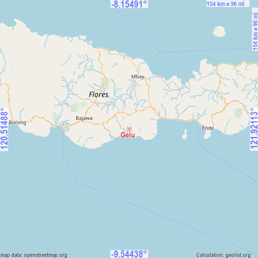
Gelu GPS coordinates[2]
8° 51' 1.08" South, 121° 13' 4.8" East
| Map corner | latitude | longitude |
|---|---|---|
| Upper-left | -8.15491°, | 120.51488° |
| Center: | -8.8503°, | 121.218° |
| Lower-right: | -9.54438°, | 121.92113° |
| Map W x H: | 154.5×154.5 km | = 96×96mi |
| max Lat: | 5.88969° ⇑92.1% North |
| Gelu: | -8.8503° |
| min Lat: | ⇓7.9% South -10.934° |
| min Long | Gelu | max Long |
| 95.1345° | 121.218° | 140.9419° |
| W 86.1%⇐ | ⇒13.9% E |
Elevation
Elevation of Gelu is 290 m = 951 ft, and this is 60.3 m = 198 ft above average elevation for this country.
| Max E: |
3185 m = 10449 ft | 30% |
| Gelu | 290 m 951 ft | |
| Avg. | 229.7 m = 754 ft | |
Min E: |
-1 m = -3 ft | 70% |
See also: Indonesia elevation on elevation.city.
Geographical zone
Gelu is located in South Torrid zone (between Equator and Tropic of Capricorn). Distance of Equator is 984.1 km =611.5 mi to North.| Distance of | km | miles | from Gelu |
|---|---|---|---|
| Equator | 984.1 | 611.5 | to North |
| Tropic Capricorn | 1621.9 | 1007.8 | to South |
| Antarctic Circle | 6417.1 | 3987.4 | to South |
| South Pole | 9023 | 5606.6 | to South |


Nearby cities:
15 places around Gelu: (largest is in red/bold)
• Dawe
1.7 km =1.1 mi,  287°
287°
• Doya
6.8 km =4.2 mi,  296°
296°
• Lokatadho
7.4 km =4.6 mi,  57°
57°
• Lokawolo
1.4 km =0.9 mi,  321°
321°
• Mauponggo
4.4 km =2.7 mi,  189°
189°
• Mbeku
7.7 km =4.8 mi,  103°
103°
• Mulakoli
5.1 km =3.2 mi,  0°
0°
• Nasawewe
7.7 km =4.8 mi,  118°
118°
• Pajoreja
2.5 km =1.6 mi,  283°
283°
• Pusu
3.8 km =2.4 mi, 59°
• Puunage
3.5 km =2.2 mi, 189°
• Sukamaju
2.8 km =1.7 mi,  256°
256°
• Wagha
6.8 km =4.2 mi,  253°
253°
• Wolonio
7.5 km =4.7 mi, 0°
• Wolowada
6.3 km =3.9 mi, 95°
Sources, notices
• [Note1] Compared only with cities in Indonesia existing in our database
• [Src1] Map data: © OpenStreetMap contributors (CC-BY-SA)
• [Src2] Other city data from geonames.org with taken over terms of usage.
• [Src3] Geographical zone / Annual Mean Temperature by Robert A. Rohde @ Wikipedia
