Pauhambar geodata
Pauhambar (West Sumatra) is a seat of a third-order administrative division; located in Indonesia in Asia/Jakarta (GMT+7) time zone. In our database, there are 407 cities with bigger population. Compared to other cities in Indonesia, 94.3% of cities are located further ↓South; 97.3% of cities are located further →East and 74.1% of cities have higher elevation than Pauhambar. Note1


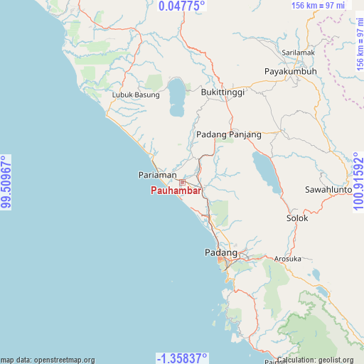
Pauhambar GPS coordinates[2]
0° 39' 19.296" South, 100° 12' 46.044" East
| Map corner | latitude | longitude |
|---|---|---|
| Upper-left | 0.04775°, | 99.50967° |
| Center: | -0.65536°, | 100.21279° |
| Lower-right: | -1.35837°, | 100.91592° |
| Map W x H: | 156.3×156.4 km | = 97.1×97.2mi |
| max Lat: | 5.88969° ⇑5.7% North |
| Pauhambar: | -0.65536° |
| min Lat: | ⇓94.3% South -10.934° |
| min Long | Pauhambar | max Long |
| 95.1345° | 100.21279° | 140.9419° |
| W 2.7%⇐ | ⇒97.3% E |
Elevation
Elevation of Pauhambar is 26 m = 85 ft, and this is 203.7 m = 668 ft below average elevation for this country.
| Max E: |
3185 m = 10449 ft | 74.1% |
| Avg. | 229.7 m = 754 ft | |
| Pauhambar | 26 m = 85 ft | |
Min E: |
-1 m = -3 ft | 25.9% |
See also: Indonesia elevation on elevation.city.
Geographical zone
Pauhambar is located in South Torrid zone (between Equator and Tropic of Capricorn). Distance of Equator is 72.9 km =45.3 mi to North.| Distance of | km | miles | from Pauhambar |
|---|---|---|---|
| Equator | 72.9 | 45.3 | to North |
| Tropic Capricorn | 2533 | 1573.9 | to South |
| Antarctic Circle | 7328.3 | 4553.6 | to South |
| South Pole | 9934.2 | 6172.8 | to South |


Nearby cities:
15 places around Pauhambar: (largest is in red/bold)
• Kampungladang
13.5 km =8.4 mi,  339°
339°
• Kotatua
38.3 km =23.8 mi,  25°
25°
• Lubuk Basung
40.2 km =25 mi, 335°
• Lubukalung
8.8 km =5.5 mi,  112°
112°
• Lubukalung
12.2 km =7.6 mi,  104°
104°
• Lubukbergalung
39.8 km =24.7 mi,  148°
148°
• Maninjau
39.5 km =24.5 mi,  2°
2°
• Padang
36.3 km =22.6 mi, 154°
• Pariaman
11.1 km =6.9 mi,  291°
291°
• Parit Malintang
8.3 km =5.2 mi,  62°
62°
• Rambatan
41.2 km =25.6 mi, 63°
• Simabur
41 km =25.5 mi, 58°
• Sungailimau
22.8 km =14.2 mi,  312°
312°
• Sungaisarik
9.2 km =5.7 mi,  8°
8°
• Tabing
28.1 km =17.5 mi, 149°
Sources, notices
• [Note1] Compared only with cities in Indonesia existing in our database
• [Src1] Map data: © OpenStreetMap contributors (CC-BY-SA)
• [Src2] Other city data from geonames.org with taken over terms of usage.
• [Src3] Geographical zone / Annual Mean Temperature by Robert A. Rohde @ Wikipedia
