Pariaman geodata
Pariaman (West Sumatra) is a seat of a third-order administrative division; located in Indonesia in Asia/Jakarta (GMT+7) time zone. With population of 92,183 people, there are 143 cities with bigger population in this country. Compared to other cities in Indonesia, 94.4% of cities are located further ↓South; 97.3% of cities are located further →East and 99.1% of cities have higher elevation than Pariaman. Note1


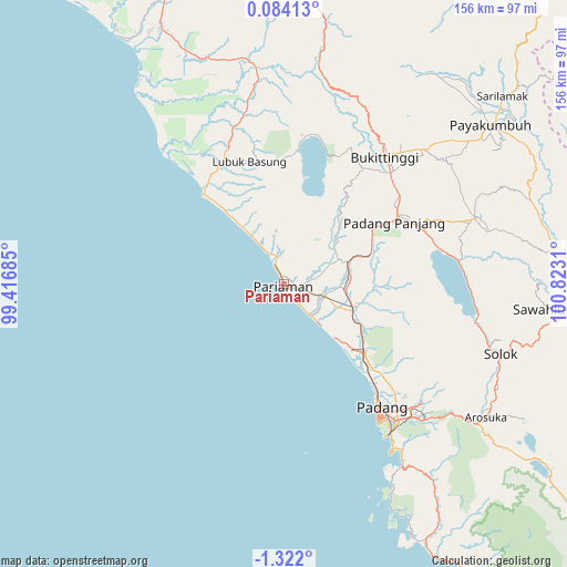
Pariaman GPS coordinates[2]
0° 37' 8.328" South, 100° 7' 11.892" East
| Map corner | latitude | longitude |
|---|---|---|
| Upper-left | 0.08413°, | 99.41685° |
| Center: | -0.61898°, | 100.11997° |
| Lower-right: | -1.322°, | 100.8231° |
| Map W x H: | 156.3×156.4 km | = 97.1×97.2mi |
| max Lat: | 5.88969° ⇑5.6% North |
| Pariaman: | -0.61898° |
| min Lat: | ⇓94.4% South -10.934° |
| min Long | Pariaman | max Long |
| 95.1345° | 100.11997° | 140.9419° |
| W 2.7%⇐ | ⇒97.3% E |
Elevation
Elevation of Pariaman is 4 m = 13 ft, and this is 225.7 m = 740 ft below average elevation for this country.
| Max E: |
3185 m = 10449 ft | 99.1% |
| Avg. | 229.7 m = 754 ft | |
| Pariaman | 4 m = 13 ft | |
Min E: |
-1 m = -3 ft | 0.9% |
See also: Pariaman elevation on elevation.city.
Geographical zone
Pariaman is located in South Torrid zone (between Equator and Tropic of Capricorn). Distance of Equator is 68.8 km =42.8 mi to North.| Distance of | km | miles | from Pariaman |
|---|---|---|---|
| Equator | 68.8 | 42.8 | to North |
| Tropic Capricorn | 2537.1 | 1576.5 | to South |
| Antarctic Circle | 7332.3 | 4556.1 | to South |
| South Pole | 9938.2 | 6175.3 | to South |


Nearby cities:
15 places around Pariaman: (largest is in red/bold)
• Bukittinggi
44.3 km =27.5 mi,  38°
38°
• Kampungladang
10.2 km =6.3 mi,  33°
33°
• Kotatua
40.7 km =25.3 mi, 41°
• Lubuk Basung
33.2 km =20.6 mi,  349°
349°
• Lubukalung
19.9 km =12.4 mi,  112°
112°
• Lubukalung
23.2 km =14.4 mi, 107°
• Maninjau
37.3 km =23.2 mi,  18°
18°
• Matur
42.2 km =26.2 mi, 26°
• Padang
45 km =28 mi,  144°
144°
• Parit Malintang
17.7 km =11 mi,  90°
90°
• Pauhambar
11.1 km =6.9 mi, 111°
• Sungailimau
13.1 km =8.1 mi,  330°
330°
• Sungaisarik
12.7 km =7.9 mi,  66°
66°
• Tabing
37.5 km =23.3 mi, 138°
• Tiku
33.1 km =20.6 mi,  318°
318°
Sources, notices
• [Note1] Compared only with cities in Indonesia existing in our database
• [Src1] Map data: © OpenStreetMap contributors (CC-BY-SA)
• [Src2] Other city data from geonames.org with taken over terms of usage.
• [Src3] Geographical zone / Annual Mean Temperature by Robert A. Rohde @ Wikipedia
