Kototujuh geodata
Kototujuh (West Sumatra) is a seat of a third-order administrative division; located in Indonesia in Asia/Jakarta (GMT+7) time zone. In our database, there are 407 cities with bigger population. Compared to other cities in Indonesia, 94.3% of cities are located further ↓South; 96.6% of cities are located further →East and 63.5% of cities have lower elevation than Kototujuh. Note1


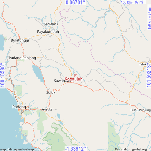
Kototujuh GPS coordinates[2]
0° 38' 9.96" South, 100° 53' 20.4" East
| Map corner | latitude | longitude |
|---|---|---|
| Upper-left | 0.06701°, | 100.18588° |
| Center: | -0.6361°, | 100.889° |
| Lower-right: | -1.33912°, | 101.59213° |
| Map W x H: | 156.3×156.4 km | = 97.1×97.2mi |
| max Lat: | 5.88969° ⇑5.7% North |
| Kototujuh: | -0.6361° |
| min Lat: | ⇓94.3% South -10.934° |
| min Long | Kototujuh | max Long |
| 95.1345° | 100.889° | 140.9419° |
| W 3.4%⇐ | ⇒96.6% E |
Elevation
Elevation of Kototujuh is 202 m = 663 ft, and this is 27.7 m = 91 ft below average elevation for this country.
| Max E: |
3185 m = 10449 ft | 36.5% |
| Avg. | 229.7 m = 754 ft | |
| Kototujuh | 202 m = 663 ft | |
Min E: |
-1 m = -3 ft | 63.5% |
See also: Indonesia elevation on elevation.city.
Geographical zone
Kototujuh is located in South Torrid zone (between Equator and Tropic of Capricorn). Distance of Equator is 70.7 km =43.9 mi to North.| Distance of | km | miles | from Kototujuh |
|---|---|---|---|
| Equator | 70.7 | 43.9 | to North |
| Tropic Capricorn | 2535.2 | 1575.3 | to South |
| Antarctic Circle | 7330.4 | 4554.9 | to South |
| South Pole | 9936.3 | 6174.1 | to South |


Nearby cities:
15 places around Kototujuh: (largest is in red/bold)
• Batusangkar
36.6 km =22.7 mi,  302°
302°
• Kumanis
11.6 km =7.2 mi,  326°
326°
• Muaro
8.3 km =5.2 mi,  111°
111°
• Saruaso
32.7 km =20.3 mi, 301°
• Sijunjung
12.2 km =7.6 mi,  126°
126°
• Singkarak
32.3 km =20.1 mi,  259°
259°
• Sirukam
31.4 km =19.5 mi,  207°
207°
• Solok
31.6 km =19.6 mi,  234°
234°
• Sulitair
26.9 km =16.7 mi,  275°
275°
• Sumpur Kudus
21.7 km =13.5 mi,  5°
5°
• Talawi
17.1 km =10.6 mi, 284°
• Tanjung Mas
20.1 km =12.5 mi,  320°
320°
• Tanjungampalu
6.8 km =4.2 mi,  267°
267°
• Tanjungampalu
7.3 km =4.5 mi, 282°
• Tanjunggadang
37.8 km =23.5 mi, 114°
Sources, notices
• [Note1] Compared only with cities in Indonesia existing in our database
• [Src1] Map data: © OpenStreetMap contributors (CC-BY-SA)
• [Src2] Other city data from geonames.org with taken over terms of usage.
• [Src3] Geographical zone / Annual Mean Temperature by Robert A. Rohde @ Wikipedia
