Kedungsumur geodata
Kedungsumur (East Java) is a seat of a fourth-order administrative division; located in Indonesia in Asia/Jakarta (GMT+7) time zone. In our database, there are 407 cities with bigger population. Compared to other cities in Indonesia, 83.3% of cities are located further ↑North; 69.1% of cities are located further ←West and 79.9% of cities have higher elevation than Kedungsumur. Note1


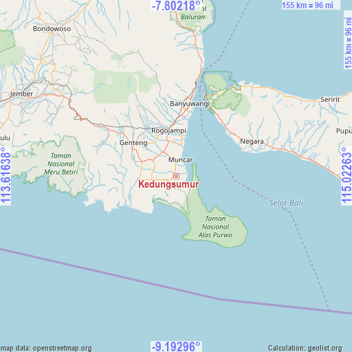
Kedungsumur GPS coordinates[2]
8° 29' 53.52" South, 114° 19' 10.2" East
| Map corner | latitude | longitude |
|---|---|---|
| Upper-left | -7.80218°, | 113.61638° |
| Center: | -8.4982°, | 114.3195° |
| Lower-right: | -9.19296°, | 115.02263° |
| Map W x H: | 154.6×154.6 km | = 96.1×96.1mi |
| max Lat: | 5.88969° ⇑83.3% North |
| Kedungsumur: | -8.4982° |
| min Lat: | ⇓16.7% South -10.934° |
| min Long | Kedungsumur | max Long |
| 95.1345° | 114.3195° | 140.9419° |
| W 69.1%⇐ | ⇒30.9% E |
Elevation
Elevation of Kedungsumur is 19 m = 62 ft, and this is 210.7 m = 691 ft below average elevation for this country.
| Max E: |
3185 m = 10449 ft | 79.9% |
| Avg. | 229.7 m = 754 ft | |
| Kedungsumur | 19 m = 62 ft | |
Min E: |
-1 m = -3 ft | 20.1% |
See also: Indonesia elevation on elevation.city.
Geographical zone
Kedungsumur is located in South Torrid zone (between Equator and Tropic of Capricorn). Distance of Equator is 944.9 km =587.1 mi to North.| Distance of | km | miles | from Kedungsumur |
|---|---|---|---|
| Equator | 944.9 | 587.1 | to North |
| Tropic Capricorn | 1661 | 1032.1 | to South |
| Antarctic Circle | 6456.3 | 4011.8 | to South |
| South Pole | 9062.2 | 5631 | to South |


Nearby cities:
15 places around Kedungsumur: (largest is in red/bold)
• Curahpacul Satu
5.6 km =3.5 mi,  324°
324°
• Jatimulyo
7.1 km =4.4 mi,  255°
255°
• Kedungrejo
6.5 km =4 mi,  0°
0°
• Kedungwringin Satu
5.2 km =3.2 mi,  18°
18°
• Kendalrejo
5.8 km =3.6 mi,  179°
179°
• Muncar
7.4 km =4.6 mi,  11°
11°
• Persen
3.7 km =2.3 mi,  171°
171°
• Rumping
5.7 km =3.5 mi,  301°
301°
• Siderejo
6.8 km =4.2 mi,  276°
276°
• Sumberberas
2.5 km =1.6 mi,  357°
357°
• Sumberkepoh
2.3 km =1.4 mi, 180°
• Sumberluhur
4.4 km =2.7 mi,  248°
248°
• Tegalsari
6.4 km =4 mi,  213°
213°
• Wringinanom Satu
3.6 km =2.2 mi,  286°
286°
• Wringinputih
2.9 km =1.8 mi,  34°
34°
Sources, notices
• [Note1] Compared only with cities in Indonesia existing in our database
• [Src1] Map data: © OpenStreetMap contributors (CC-BY-SA)
• [Src2] Other city data from geonames.org with taken over terms of usage.
• [Src3] Geographical zone / Annual Mean Temperature by Robert A. Rohde @ Wikipedia
