Muncar geodata
Muncar (East Java) is a populated place; located in Indonesia in Asia/Jakarta (GMT+7) time zone. With population of 64,537 people, there are 189 cities with bigger population in this country. Compared to other cities in Indonesia, 81.2% of cities are located further ↑North; 69.2% of cities are located further ←West and 97.2% of cities have higher elevation than Muncar. Note1


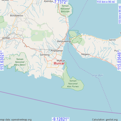
Muncar GPS coordinates[2]
8° 25' 59.988" South, 114° 19' 59.988" East
| Map corner | latitude | longitude |
|---|---|---|
| Upper-left | -7.7372°, | 113.63021° |
| Center: | -8.43333°, | 114.33333° |
| Lower-right: | -9.12821°, | 115.03646° |
| Map W x H: | 154.7×154.7 km | = 96.1×96.1mi |
| max Lat: | 5.88969° ⇑81.2% North |
| Muncar: | -8.43333° |
| min Lat: | ⇓18.8% South -10.934° |
| min Long | Muncar | max Long |
| 95.1345° | 114.33333° | 140.9419° |
| W 69.2%⇐ | ⇒30.8% E |
Elevation
Elevation of Muncar is 6 m = 20 ft, and this is 223.7 m = 734 ft below average elevation for this country.
| Max E: |
3185 m = 10449 ft | 97.2% |
| Avg. | 229.7 m = 754 ft | |
| Muncar | 6 m = 20 ft | |
Min E: |
-1 m = -3 ft | 2.8% |
See also: Muncar elevation on elevation.city.
Geographical zone
Muncar is located in South Torrid zone (between Equator and Tropic of Capricorn). Distance of Equator is 937.7 km =582.7 mi to North.| Distance of | km | miles | from Muncar |
|---|---|---|---|
| Equator | 937.7 | 582.7 | to North |
| Tropic Capricorn | 1668.2 | 1036.6 | to South |
| Antarctic Circle | 6463.5 | 4016.2 | to South |
| South Pole | 9069.4 | 5635.5 | to South |


Nearby cities:
15 places around Muncar: (largest is in red/bold)
• Bagorejo
5.2 km =3.2 mi,  322°
322°
• Curahpacul Satu
5.4 km =3.4 mi,  240°
240°
• Karanglo
8.2 km =5.1 mi,  311°
311°
• Kedungrejo
1.6 km =1 mi, 242°
• Kedungsumur
7.4 km =4.6 mi,  191°
191°
• Kedungwringin Satu
2.3 km =1.4 mi,  176°
176°
• Kumendung Satu
5.6 km =3.5 mi,  359°
359°
• Rejoagung Satu
6.6 km =4.1 mi,  337°
337°
• Rumping
7.7 km =4.8 mi, 236°
• Srono
8.2 km =5.1 mi,  296°
296°
• Sumberan
8.1 km =5 mi, 297°
• Sumberberas
5 km =3.1 mi,  198°
198°
• Sumbersewu
3.6 km =2.2 mi,  348°
348°
• Wringinanom Satu
7.9 km =4.9 mi,  218°
218°
• Wringinputih
4.8 km =3 mi, 178°
Sources, notices
• [Note1] Compared only with cities in Indonesia existing in our database
• [Src1] Map data: © OpenStreetMap contributors (CC-BY-SA)
• [Src2] Other city data from geonames.org with taken over terms of usage.
• [Src3] Geographical zone / Annual Mean Temperature by Robert A. Rohde @ Wikipedia
