Jorowaru Daya geodata
Jorowaru Daya (West Nusa Tenggara) is a seat of a fourth-order administrative division; located in Indonesia in Asia/Makassar (GMT+8) time zone. In our database, there are 407 cities with bigger population. Compared to other cities in Indonesia, 91.2% of cities are located further ↑North; 77.5% of cities are located further ←West and 61.8% of cities have higher elevation than Jorowaru Daya. Note1


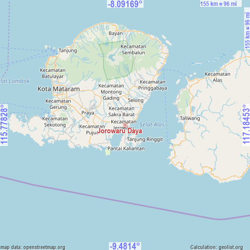
Jorowaru Daya GPS coordinates[2]
8° 47' 13.92" South, 116° 28' 53.04" East
| Map corner | latitude | longitude |
|---|---|---|
| Upper-left | -8.09169°, | 115.77828° |
| Center: | -8.7872°, | 116.4814° |
| Lower-right: | -9.4814°, | 117.18453° |
| Map W x H: | 154.5×154.5 km | = 96×96mi |
| max Lat: | 5.88969° ⇑91.2% North |
| Jorowaru Daya: | -8.7872° |
| min Lat: | ⇓8.8% South -10.934° |
| min Long | Jorowaru Daya | max Long |
| 95.1345° | 116.4814° | 140.9419° |
| W 77.5%⇐ | ⇒22.5% E |
Elevation
Elevation of Jorowaru Daya is 52 m = 171 ft, and this is 177.7 m = 583 ft below average elevation for this country.
| Max E: |
3185 m = 10449 ft | 61.8% |
| Avg. | 229.7 m = 754 ft | |
| Jorowaru Daya | 52 m = 171 ft | |
Min E: |
-1 m = -3 ft | 38.2% |
See also: Indonesia elevation on elevation.city.
Geographical zone
Jorowaru Daya is located in South Torrid zone (between Equator and Tropic of Capricorn). Distance of Equator is 977 km =607.1 mi to North.| Distance of | km | miles | from Jorowaru Daya |
|---|---|---|---|
| Equator | 977 | 607.1 | to North |
| Tropic Capricorn | 1628.9 | 1012.2 | to South |
| Antarctic Circle | 6424.1 | 3991.7 | to South |
| South Pole | 9030 | 5611 | to South |


Nearby cities:
15 places around Jorowaru Daya: (largest is in red/bold)
• Bungtiang Barat
6.3 km =3.9 mi,  2°
2°
• Gunungrajak
9.2 km =5.7 mi,  347°
347°
• Lekor Barat
8.1 km =5 mi,  321°
321°
• Lepak
9.4 km =5.8 mi,  12°
12°
• Mandikbatu
7.9 km =4.9 mi,  19°
19°
• Meringkik
6.3 km =3.9 mi,  121°
121°
• Montongtebolak
7 km =4.3 mi,  344°
344°
• Pemongkong
6.4 km =4 mi,  179°
179°
• Pengkelakmas
6.2 km =3.9 mi, 18°
• Sagikmateng
9.3 km =5.8 mi,  240°
240°
• Selebung
2.5 km =1.6 mi, 1°
• Sepit
5.5 km =3.4 mi, 335°
• Sukarara Utara
9.6 km =6 mi,  333°
333°
• Tanjungluar
4.2 km =2.6 mi,  71°
71°
• Timukpeken
8.8 km =5.5 mi,  34°
34°
Sources, notices
• [Note1] Compared only with cities in Indonesia existing in our database
• [Src1] Map data: © OpenStreetMap contributors (CC-BY-SA)
• [Src2] Other city data from geonames.org with taken over terms of usage.
• [Src3] Geographical zone / Annual Mean Temperature by Robert A. Rohde @ Wikipedia
