Gunungrajak geodata
Gunungrajak (West Nusa Tenggara) is a seat of a fourth-order administrative division; located in Indonesia in Asia/Makassar (GMT+8) time zone. In our database, there are 407 cities with bigger population. Compared to other cities in Indonesia, 89.4% of cities are located further ↑North; 77.4% of cities are located further ←West and 65.7% of cities have lower elevation than Gunungrajak. Note1


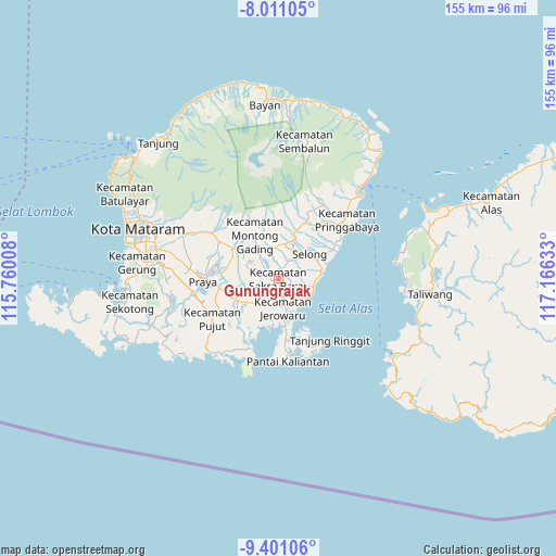
Gunungrajak GPS coordinates[2]
8° 42' 24.12" South, 116° 27' 47.52" East
| Map corner | latitude | longitude |
|---|---|---|
| Upper-left | -8.01105°, | 115.76008° |
| Center: | -8.7067°, | 116.4632° |
| Lower-right: | -9.40106°, | 117.16633° |
| Map W x H: | 154.6×154.6 km | = 96.1×96.1mi |
| max Lat: | 5.88969° ⇑89.4% North |
| Gunungrajak: | -8.7067° |
| min Lat: | ⇓10.6% South -10.934° |
| min Long | Gunungrajak | max Long |
| 95.1345° | 116.4632° | 140.9419° |
| W 77.4%⇐ | ⇒22.6% E |
Elevation
Elevation of Gunungrajak is 231 m = 758 ft, and this is 1.3 m = 4 ft above average elevation for this country.
| Max E: |
3185 m = 10449 ft | 34.3% |
| Gunungrajak | 231 m 758 ft | |
| Avg. | 229.7 m = 754 ft | |
Min E: |
-1 m = -3 ft | 65.7% |
See also: Indonesia elevation on elevation.city.
Geographical zone
Gunungrajak is located in South Torrid zone (between Equator and Tropic of Capricorn). Distance of Equator is 968.1 km =601.5 mi to North.| Distance of | km | miles | from Gunungrajak |
|---|---|---|---|
| Equator | 968.1 | 601.5 | to North |
| Tropic Capricorn | 1637.8 | 1017.7 | to South |
| Antarctic Circle | 6433.1 | 3997.3 | to South |
| South Pole | 9039 | 5616.6 | to South |


Nearby cities:
15 places around Gunungrajak: (largest is in red/bold)
• Bungtiang Barat
3.5 km =2.2 mi,  139°
139°
• Dalam Daya
3.1 km =1.9 mi,  15°
15°
• Kabar Utara
5.3 km =3.3 mi, 15°
• Lekor Barat
4.1 km =2.5 mi,  229°
229°
• Lepak
4.1 km =2.5 mi,  87°
87°
• Lintek
4.9 km =3 mi,  351°
351°
• Mandikbatu
4.8 km =3 mi,  107°
107°
• Montongtangi Timuk
4.1 km =2.5 mi,  57°
57°
• Montongtebolak
2.2 km =1.4 mi,  176°
176°
• Pancoran
5.5 km =3.4 mi,  29°
29°
• Pengkelakmas
5 km =3.1 mi,  127°
127°
• Sakra
2.6 km =1.6 mi,  357°
357°
• Sepit
3.9 km =2.4 mi, 184°
• Sukarara Utara
2.3 km =1.4 mi,  261°
261°
• Suwangi Utara
2.6 km =1.6 mi,  305°
305°
Sources, notices
• [Note1] Compared only with cities in Indonesia existing in our database
• [Src1] Map data: © OpenStreetMap contributors (CC-BY-SA)
• [Src2] Other city data from geonames.org with taken over terms of usage.
• [Src3] Geographical zone / Annual Mean Temperature by Robert A. Rohde @ Wikipedia
