Lekor Barat geodata
Lekor Barat (West Nusa Tenggara) is a seat of a fourth-order administrative division; located in Indonesia in Asia/Makassar (GMT+8) time zone. In our database, there are 407 cities with bigger population. Compared to other cities in Indonesia, 90% of cities are located further ↑North; 77.2% of cities are located further ←West and 55.2% of cities have lower elevation than Lekor Barat. Note1


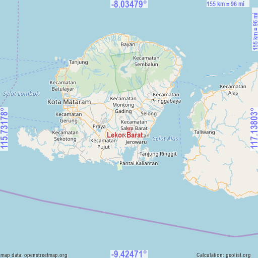
Lekor Barat GPS coordinates[2]
8° 43' 49.44" South, 116° 26' 5.64" East
| Map corner | latitude | longitude |
|---|---|---|
| Upper-left | -8.03479°, | 115.73178° |
| Center: | -8.7304°, | 116.4349° |
| Lower-right: | -9.42471°, | 117.13803° |
| Map W x H: | 154.5×154.5 km | = 96×96mi |
| max Lat: | 5.88969° ⇑90% North |
| Lekor Barat: | -8.7304° |
| min Lat: | ⇓10% South -10.934° |
| min Long | Lekor Barat | max Long |
| 95.1345° | 116.4349° | 140.9419° |
| W 77.2%⇐ | ⇒22.8% E |
Elevation
Elevation of Lekor Barat is 126 m = 413 ft, and this is 103.7 m = 340 ft below average elevation for this country.
| Max E: |
3185 m = 10449 ft | 44.8% |
| Avg. | 229.7 m = 754 ft | |
| Lekor Barat | 126 m = 413 ft | |
Min E: |
-1 m = -3 ft | 55.2% |
See also: Indonesia elevation on elevation.city.
Geographical zone
Lekor Barat is located in South Torrid zone (between Equator and Tropic of Capricorn). Distance of Equator is 970.7 km =603.2 mi to North.| Distance of | km | miles | from Lekor Barat |
|---|---|---|---|
| Equator | 970.7 | 603.2 | to North |
| Tropic Capricorn | 1635.2 | 1016.1 | to South |
| Antarctic Circle | 6430.4 | 3995.7 | to South |
| South Pole | 9036.3 | 5614.9 | to South |


Nearby cities:
15 places around Lekor Barat: (largest is in red/bold)
• Beleka Satu
3.7 km =2.3 mi,  249°
249°
• Bungtiang Barat
5.4 km =3.4 mi,  90°
90°
• Dalam Daya
6.8 km =4.2 mi,  34°
34°
• Ganti Dua
6.1 km =3.8 mi,  225°
225°
• Gunungrajak
4.1 km =2.5 mi,  49°
49°
• Janapria
5.4 km =3.4 mi,  316°
316°
• Jembe Timur
3.1 km =1.9 mi,  303°
303°
• Loangmaka
4.9 km =3 mi,  291°
291°
• Montongtebolak
3.3 km =2.1 mi,  81°
81°
• Pengkelakmas
7.1 km =4.4 mi, 93°
• Sakra
6 km =3.7 mi, 29°
• Selebung
6.5 km =4 mi,  126°
126°
• Sepit
3.1 km =1.9 mi,  114°
114°
• Sukarara Utara
2.5 km =1.6 mi,  20°
20°
• Suwangi Utara
4.2 km =2.6 mi,  13°
13°
Sources, notices
• [Note1] Compared only with cities in Indonesia existing in our database
• [Src1] Map data: © OpenStreetMap contributors (CC-BY-SA)
• [Src2] Other city data from geonames.org with taken over terms of usage.
• [Src3] Geographical zone / Annual Mean Temperature by Robert A. Rohde @ Wikipedia
