Ende geodata
Ende (East Nusa Tenggara) is a seat of a second-order administrative division; located in Indonesia in Asia/Makassar (GMT+8) time zone. With population of 77,205 people, there are 166 cities with bigger population in this country. Compared to other cities in Indonesia, 92% of cities are located further ↑North; 87% of cities are located further ←West and 70.7% of cities have higher elevation than Ende. Note1


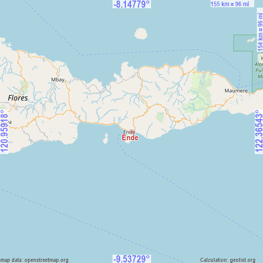
Ende GPS coordinates[2]
8° 50' 35.52" South, 121° 39' 44.28" East
| Map corner | latitude | longitude |
|---|---|---|
| Upper-left | -8.14779°, | 120.95918° |
| Center: | -8.8432°, | 121.6623° |
| Lower-right: | -9.53729°, | 122.36543° |
| Map W x H: | 154.5×154.5 km | = 96×96mi |
| max Lat: | 5.88969° ⇑92% North |
| Ende: | -8.8432° |
| min Lat: | ⇓8% South -10.934° |
| min Long | Ende | max Long |
| 95.1345° | 121.6623° | 140.9419° |
| W 87%⇐ | ⇒13% E |
Elevation
Elevation of Ende is 31 m = 102 ft, and this is 198.7 m = 652 ft below average elevation for this country.
| Max E: |
3185 m = 10449 ft | 70.7% |
| Avg. | 229.7 m = 754 ft | |
| Ende | 31 m = 102 ft | |
Min E: |
-1 m = -3 ft | 29.3% |
See also: Ende elevation on elevation.city.
Geographical zone
Ende is located in South Torrid zone (between Equator and Tropic of Capricorn). Distance of Equator is 983.3 km =611 mi to North.| Distance of | km | miles | from Ende |
|---|---|---|---|
| Equator | 983.3 | 611 | to North |
| Tropic Capricorn | 1622.6 | 1008.2 | to South |
| Antarctic Circle | 6417.9 | 3987.9 | to South |
| South Pole | 9023.8 | 5607.1 | to South |


Nearby cities:
15 places around Ende: (largest is in red/bold)
• Aemura
3.9 km =2.4 mi,  10°
10°
• Lokoboko
3.3 km =2.1 mi,  37°
37°
• Mautapaga Bawah
1.1 km =0.7 mi,  100°
100°
• Mbomba
4.9 km =3 mi,  289°
289°
• Mbongawani
2 km =1.2 mi,  258°
258°
• Ndona
2.8 km =1.7 mi,  68°
68°
• Nuakota
4.2 km =2.6 mi, 68°
• Onekore
1.4 km =0.9 mi,  302°
302°
• Onewitu
2 km =1.2 mi,  281°
281°
• Paupanda Bawah
2.5 km =1.6 mi,  236°
236°
• Potulando
1.2 km =0.7 mi,  249°
249°
• Rukunlima Bawah
2.2 km =1.4 mi, 246°
• Tetandara
1.1 km =0.7 mi,  204°
204°
• Wolonio
2.8 km =1.7 mi,  310°
310°
• Wolowona
2 km =1.2 mi,  51°
51°
Sources, notices
• [Note1] Compared only with cities in Indonesia existing in our database
• [Src1] Map data: © OpenStreetMap contributors (CC-BY-SA)
• [Src2] Other city data from geonames.org with taken over terms of usage.
• [Src3] Geographical zone / Annual Mean Temperature by Robert A. Rohde @ Wikipedia
