Gogosan geodata
Gogosan (East Java) is a seat of a fourth-order administrative division; located in Indonesia in Asia/Jakarta (GMT+7) time zone. In our database, there are 407 cities with bigger population. Compared to other cities in Indonesia, 73.2% of cities are located further ↑North; 60.5% of cities are located further ←West and 75.5% of cities have higher elevation than Gogosan. Note1


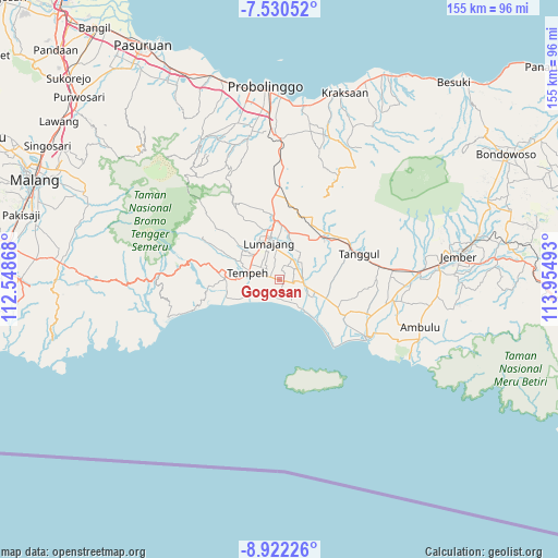
Gogosan GPS coordinates[2]
8° 13' 37.2" South, 113° 15' 6.48" East
| Map corner | latitude | longitude |
|---|---|---|
| Upper-left | -7.53052°, | 112.54868° |
| Center: | -8.227°, | 113.2518° |
| Lower-right: | -8.92226°, | 113.95493° |
| Map W x H: | 154.7×154.8 km | = 96.1×96.2mi |
| max Lat: | 5.88969° ⇑73.2% North |
| Gogosan: | -8.227° |
| min Lat: | ⇓26.8% South -10.934° |
| min Long | Gogosan | max Long |
| 95.1345° | 113.2518° | 140.9419° |
| W 60.5%⇐ | ⇒39.5% E |
Elevation
Elevation of Gogosan is 24 m = 79 ft, and this is 205.7 m = 675 ft below average elevation for this country.
| Max E: |
3185 m = 10449 ft | 75.5% |
| Avg. | 229.7 m = 754 ft | |
| Gogosan | 24 m = 79 ft | |
Min E: |
-1 m = -3 ft | 24.5% |
See also: Indonesia elevation on elevation.city.
Geographical zone
Gogosan is located in South Torrid zone (between Equator and Tropic of Capricorn). Distance of Equator is 914.8 km =568.4 mi to North.| Distance of | km | miles | from Gogosan |
|---|---|---|---|
| Equator | 914.8 | 568.4 | to North |
| Tropic Capricorn | 1691.2 | 1050.9 | to South |
| Antarctic Circle | 6486.4 | 4030.5 | to South |
| South Pole | 9092.3 | 5649.7 | to South |


Nearby cities:
15 places around Gogosan: (largest is in red/bold)
• Besukrejo
4.8 km =3 mi,  343°
343°
• Darunban
3.9 km =2.4 mi,  16°
16°
• Darungan
2.5 km =1.6 mi,  169°
169°
• Jatiarum
3.8 km =2.4 mi,  240°
240°
• Karangsari
1.1 km =0.7 mi,  91°
91°
• Kebonan
2.9 km =1.8 mi,  294°
294°
• Ketangi
3.4 km =2.1 mi,  276°
276°
• Krajan Krai
2.9 km =1.8 mi,  119°
119°
• Mentosari
4.4 km =2.7 mi, 279°
• Pandean
4 km =2.5 mi,  265°
265°
• Recobanteng
5 km =3.1 mi,  309°
309°
• Sidomulyo
4.1 km =2.5 mi,  149°
149°
• Sukolilo
1.8 km =1.1 mi, 282°
• Sumberwongso
4.9 km =3 mi,  217°
217°
• Tulusmulyo
0.9 km =0.6 mi,  44°
44°
Sources, notices
• [Note1] Compared only with cities in Indonesia existing in our database
• [Src1] Map data: © OpenStreetMap contributors (CC-BY-SA)
• [Src2] Other city data from geonames.org with taken over terms of usage.
• [Src3] Geographical zone / Annual Mean Temperature by Robert A. Rohde @ Wikipedia
