Recobanteng geodata
Recobanteng (East Java) is a seat of a fourth-order administrative division; located in Indonesia in Asia/Jakarta (GMT+7) time zone. In our database, there are 407 cities with bigger population. Compared to other cities in Indonesia, 71.5% of cities are located further ↑North; 60.2% of cities are located further ←West and 59.8% of cities have higher elevation than Recobanteng. Note1


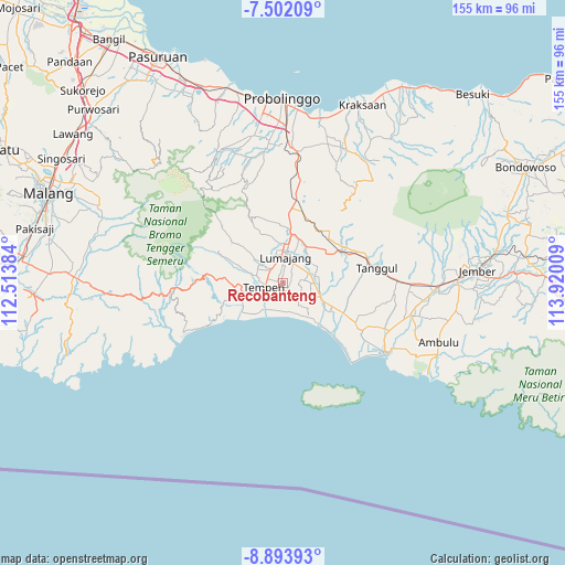
Recobanteng GPS coordinates[2]
8° 11' 55.032" South, 113° 13' 1.056" East
| Map corner | latitude | longitude |
|---|---|---|
| Upper-left | -7.50209°, | 112.51384° |
| Center: | -8.19862°, | 113.21696° |
| Lower-right: | -8.89393°, | 113.92009° |
| Map W x H: | 154.8×154.8 km | = 96.2×96.2mi |
| max Lat: | 5.88969° ⇑71.5% North |
| Recobanteng: | -8.19862° |
| min Lat: | ⇓28.5% South -10.934° |
| min Long | Recobanteng | max Long |
| 95.1345° | 113.21696° | 140.9419° |
| W 60.2%⇐ | ⇒39.8% E |
Elevation
Elevation of Recobanteng is 60 m = 197 ft, and this is 169.7 m = 557 ft below average elevation for this country.
| Max E: |
3185 m = 10449 ft | 59.8% |
| Avg. | 229.7 m = 754 ft | |
| Recobanteng | 60 m = 197 ft | |
Min E: |
-1 m = -3 ft | 40.2% |
See also: Indonesia elevation on elevation.city.
Geographical zone
Recobanteng is located in South Torrid zone (between Equator and Tropic of Capricorn). Distance of Equator is 911.6 km =566.4 mi to North.| Distance of | km | miles | from Recobanteng |
|---|---|---|---|
| Equator | 911.6 | 566.4 | to North |
| Tropic Capricorn | 1694.3 | 1052.8 | to South |
| Antarctic Circle | 6489.6 | 4032.4 | to South |
| South Pole | 9095.5 | 5651.7 | to South |


Nearby cities:
15 places around Recobanteng: (largest is in red/bold)
• Bedok Dua
4.3 km =2.7 mi,  286°
286°
• Besukan
4 km =2.5 mi,  35°
35°
• Besukrejo
2.8 km =1.7 mi,  59°
59°
• Darunban
5 km =3.1 mi,  83°
83°
• Gogosan
5 km =3.1 mi,  129°
129°
• Grati Satu
5.1 km =3.2 mi,  0°
0°
• Kebonan
2.3 km =1.4 mi,  147°
147°
• Ketangi
2.8 km =1.7 mi,  170°
170°
• Krajan Tengah
2.9 km =1.8 mi,  233°
233°
• Mentosari
2.5 km =1.6 mi,  192°
192°
• Pandean
3.5 km =2.2 mi,  182°
182°
• Suko Dua
4.7 km =2.9 mi,  316°
316°
• Sukolilo
3.5 km =2.2 mi,  142°
142°
• Sumberbendo
1.3 km =0.8 mi,  352°
352°
• Tempeh Tengah
4.6 km =2.9 mi,  260°
260°
Sources, notices
• [Note1] Compared only with cities in Indonesia existing in our database
• [Src1] Map data: © OpenStreetMap contributors (CC-BY-SA)
• [Src2] Other city data from geonames.org with taken over terms of usage.
• [Src3] Geographical zone / Annual Mean Temperature by Robert A. Rohde @ Wikipedia
