Kebonan geodata
Kebonan (East Java) is a seat of a third-order administrative division; located in Indonesia in Asia/Jakarta (GMT+7) time zone. In our database, there are 407 cities with bigger population. Compared to other cities in Indonesia, 72.6% of cities are located further ↑North; 60.3% of cities are located further ←West and 64.8% of cities have higher elevation than Kebonan. Note1


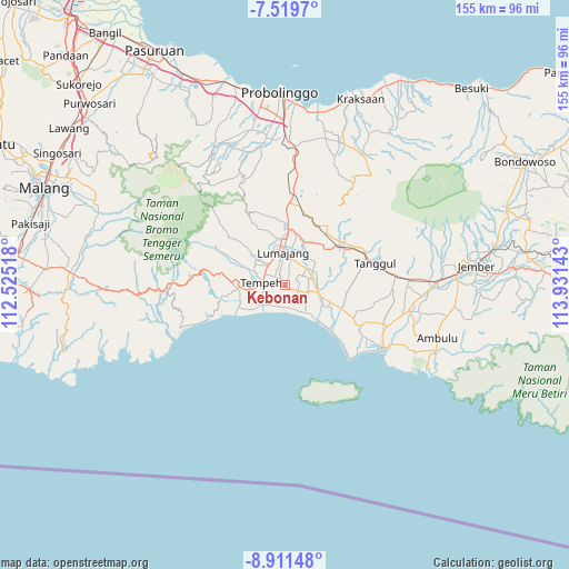
Kebonan GPS coordinates[2]
8° 12' 58.32" South, 113° 13' 41.88" East
| Map corner | latitude | longitude |
|---|---|---|
| Upper-left | -7.5197°, | 112.52518° |
| Center: | -8.2162°, | 113.2283° |
| Lower-right: | -8.91148°, | 113.93143° |
| Map W x H: | 154.8×154.8 km | = 96.2×96.2mi |
| max Lat: | 5.88969° ⇑72.6% North |
| Kebonan: | -8.2162° |
| min Lat: | ⇓27.4% South -10.934° |
| min Long | Kebonan | max Long |
| 95.1345° | 113.2283° | 140.9419° |
| W 60.3%⇐ | ⇒39.7% E |
Elevation
Elevation of Kebonan is 43 m = 141 ft, and this is 186.7 m = 613 ft below average elevation for this country.
| Max E: |
3185 m = 10449 ft | 64.8% |
| Avg. | 229.7 m = 754 ft | |
| Kebonan | 43 m = 141 ft | |
Min E: |
-1 m = -3 ft | 35.2% |
See also: Indonesia elevation on elevation.city.
Geographical zone
Kebonan is located in South Torrid zone (between Equator and Tropic of Capricorn). Distance of Equator is 913.6 km =567.7 mi to North.| Distance of | km | miles | from Kebonan |
|---|---|---|---|
| Equator | 913.6 | 567.7 | to North |
| Tropic Capricorn | 1692.4 | 1051.6 | to South |
| Antarctic Circle | 6487.6 | 4031.2 | to South |
| South Pole | 9093.5 | 5650.4 | to South |


Nearby cities:
15 places around Kebonan: (largest is in red/bold)
• Besukrejo
3.6 km =2.2 mi,  19°
19°
• Cengkok
4.4 km =2.7 mi,  232°
232°
• Darunban
4.5 km =2.8 mi,  55°
55°
• Darungan
4.7 km =2.9 mi,  140°
140°
• Gogosan
2.9 km =1.8 mi,  114°
114°
• Jatiarum
3.2 km =2 mi,  193°
193°
• Karangsari
3.9 km =2.4 mi, 108°
• Ketangi
1.1 km =0.7 mi, 225°
• Krajan Tengah
3.6 km =2.2 mi,  273°
273°
• Mentosari
1.8 km =1.1 mi,  255°
255°
• Pandean
2 km =1.2 mi,  222°
222°
• Recobanteng
2.3 km =1.4 mi,  327°
327°
• Sukolilo
1.2 km =0.7 mi,  133°
133°
• Sumberbendo
3.5 km =2.2 mi,  336°
336°
• Tulusmulyo
3.3 km =2.1 mi,  99°
99°
Sources, notices
• [Note1] Compared only with cities in Indonesia existing in our database
• [Src1] Map data: © OpenStreetMap contributors (CC-BY-SA)
• [Src2] Other city data from geonames.org with taken over terms of usage.
• [Src3] Geographical zone / Annual Mean Temperature by Robert A. Rohde @ Wikipedia
