Banjar Pasekan geodata
Banjar Pasekan (Bali) is a seat of a fourth-order administrative division; located in Indonesia in Asia/Makassar (GMT+8) time zone. In our database, there are 407 cities with bigger population. Compared to other cities in Indonesia, 87.7% of cities are located further ↑North; 73.4% of cities are located further ←West and 81.9% of cities have higher elevation than Banjar Pasekan. Note1


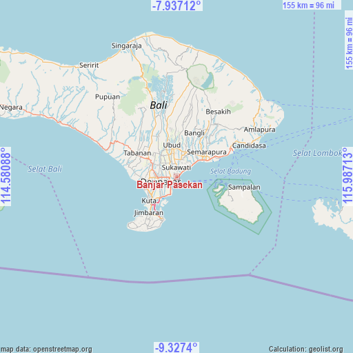
Banjar Pasekan GPS coordinates[2]
8° 37' 58.44" South, 115° 17' 2.4" East
| Map corner | latitude | longitude |
|---|---|---|
| Upper-left | -7.93712°, | 114.58088° |
| Center: | -8.6329°, | 115.284° |
| Lower-right: | -9.3274°, | 115.98713° |
| Map W x H: | 154.6×154.6 km | = 96.1×96.1mi |
| max Lat: | 5.88969° ⇑87.7% North |
| Banjar Pasekan: | -8.6329° |
| min Lat: | ⇓12.3% South -10.934° |
| min Long | Banjar Pasekan | max Long |
| 95.1345° | 115.284° | 140.9419° |
| W 73.4%⇐ | ⇒26.6% E |
Elevation
Elevation of Banjar Pasekan is 17 m = 56 ft, and this is 212.7 m = 698 ft below average elevation for this country.
| Max E: |
3185 m = 10449 ft | 81.9% |
| Avg. | 229.7 m = 754 ft | |
| Banjar Pasekan | 17 m = 56 ft | |
Min E: |
-1 m = -3 ft | 18.1% |
See also: Indonesia elevation on elevation.city.
Geographical zone
Banjar Pasekan is located in South Torrid zone (between Equator and Tropic of Capricorn). Distance of Equator is 959.9 km =596.5 mi to North.| Distance of | km | miles | from Banjar Pasekan |
|---|---|---|---|
| Equator | 959.9 | 596.5 | to North |
| Tropic Capricorn | 1646 | 1022.8 | to South |
| Antarctic Circle | 6441.3 | 4002.4 | to South |
| South Pole | 9047.2 | 5621.7 | to South |


Nearby cities:
15 places around Banjar Pasekan: (largest is in red/bold)
• Banjar Batanpoh
5.6 km =3.5 mi,  210°
210°
• Banjar Batur
8.6 km =5.3 mi,  295°
295°
• Banjar Desa
7.4 km =4.6 mi,  319°
319°
• Banjar Jabejero
6.1 km =3.8 mi,  308°
308°
• Banjar Kayangan
6.1 km =3.8 mi,  280°
280°
• Banjar Kertajiwa
2.6 km =1.6 mi,  251°
251°
• Banjar Kertasari
8.2 km =5.1 mi, 278°
• Banjar Medura
7.4 km =4.6 mi, 206°
• Banjar Paangkelod
4.9 km =3 mi, 281°
• Banjar Parekan
9.7 km =6 mi, 310°
• Banjar Pemangkalan
9.3 km =5.8 mi, 275°
• Banjar Sedang
8.5 km =5.3 mi, 324°
• Banjar Taman
6.2 km =3.9 mi, 209°
• Dajan Tangluk
5.2 km =3.2 mi, 253°
• Denpasar
7.6 km =4.7 mi,  255°
255°
Sources, notices
• [Note1] Compared only with cities in Indonesia existing in our database
• [Src1] Map data: © OpenStreetMap contributors (CC-BY-SA)
• [Src2] Other city data from geonames.org with taken over terms of usage.
• [Src3] Geographical zone / Annual Mean Temperature by Robert A. Rohde @ Wikipedia
