Gadingrejo geodata
Gadingrejo (East Java) is a seat of a fourth-order administrative division; located in Indonesia in Asia/Jakarta (GMT+7) time zone. In our database, there are 407 cities with bigger population. Compared to other cities in Indonesia, 73.6% of cities are located further ↑North; 61.6% of cities are located further ←West and 75.5% of cities have higher elevation than Gadingrejo. Note1


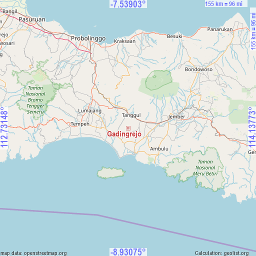
Gadingrejo GPS coordinates[2]
8° 14' 7.8" South, 113° 26' 4.56" East
| Map corner | latitude | longitude |
|---|---|---|
| Upper-left | -7.53903°, | 112.73148° |
| Center: | -8.2355°, | 113.4346° |
| Lower-right: | -8.93075°, | 114.13773° |
| Map W x H: | 154.7×154.7 km | = 96.1×96.1mi |
| max Lat: | 5.88969° ⇑73.6% North |
| Gadingrejo: | -8.2355° |
| min Lat: | ⇓26.4% South -10.934° |
| min Long | Gadingrejo | max Long |
| 95.1345° | 113.4346° | 140.9419° |
| W 61.6%⇐ | ⇒38.4% E |
Elevation
Elevation of Gadingrejo is 24 m = 79 ft, and this is 205.7 m = 675 ft below average elevation for this country.
| Max E: |
3185 m = 10449 ft | 75.5% |
| Avg. | 229.7 m = 754 ft | |
| Gadingrejo | 24 m = 79 ft | |
Min E: |
-1 m = -3 ft | 24.5% |
See also: Indonesia elevation on elevation.city.
Geographical zone
Gadingrejo is located in South Torrid zone (between Equator and Tropic of Capricorn). Distance of Equator is 915.7 km =569 mi to North.| Distance of | km | miles | from Gadingrejo |
|---|---|---|---|
| Equator | 915.7 | 569 | to North |
| Tropic Capricorn | 1690.2 | 1050.2 | to South |
| Antarctic Circle | 6485.5 | 4029.9 | to South |
| South Pole | 9091.4 | 5649.1 | to South |


Nearby cities:
15 places around Gadingrejo: (largest is in red/bold)
• Gununglincingkrajan
2.3 km =1.4 mi,  192°
192°
• Kebonsari
3.5 km =2.2 mi,  155°
155°
• Kebonsari Kidul
4.9 km =3 mi, 157°
• Kesambilerenkrajan
5.7 km =3.5 mi,  211°
211°
• Ngampelrejo
6.6 km =4.1 mi,  285°
285°
• Paleran
6.8 km =4.2 mi,  79°
79°
• Rejoagung
4.2 km =2.6 mi,  332°
332°
• Rejosarikrajan
4.9 km =3 mi, 187°
• Rowotengu
7.4 km =4.6 mi,  352°
352°
• Semboro Lor
5.2 km =3.2 mi,  12°
12°
• Semboropasar
3 km =1.9 mi,  22°
22°
• Sidomekar
4 km =2.5 mi,  46°
46°
• Sukoreno
4 km =2.5 mi,  250°
250°
• Umbulsari
2.9 km =1.8 mi, 157°
• Wringinagung
5.7 km =3.5 mi,  303°
303°
Sources, notices
• [Note1] Compared only with cities in Indonesia existing in our database
• [Src1] Map data: © OpenStreetMap contributors (CC-BY-SA)
• [Src2] Other city data from geonames.org with taken over terms of usage.
• [Src3] Geographical zone / Annual Mean Temperature by Robert A. Rohde @ Wikipedia
